NASA identifies the areas of Tropical Storm Muifa's strength
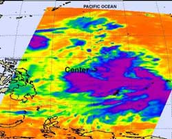
NASA's Aqua satellite passed over Tropical Storm Muifa and the AIRS instrument captured this infrared image of the storm's cold cloud tops (purple) and strong thunderstorms on July 27 at 1647 UTC (12:47 p.m. EDT). The storm's center is identified here. The Philippines are located to the west and can be seen on the left side of the image. Credit: NASA JPL, Ed Olsen<br>
Tropical Storm Muifa is moving through the western North Pacific Ocean, and had strengthened during the early morning hours of July 28. On July 27, it was tropical depression 11W and winds have since increased to 40 knots (46 mph/74 kmh).
When NASA's Aqua satellite passed over Tropical Storm Muifa the Atmospheric Infrared Sounder (AIRS) instrument captured an infrared look at the storm's cold cloud tops and strong thunderstorms. The colder the cloud tops, the higher the thunderstorms and the stronger they are. The AIRS infrared image on July 27 at 1647 UTC (12:47 p.m. EDT) showed that the highest, coldest thunderstorms were on the eastern and southern sides of the center.
So why doesn't the northern side of Tropical Storm Muifa have any strong convection (rapidly rising air that form thunderstorms that make up the storm)? The answer is that Muifa is located 10 degrees southeast of a high pressure area in the western North Pacific Ocean that is preventing evaporation in the storm's northern quadrant. The high pressure area is pushing air downward toward the surface and preventing evaporation and formation of thunderstorms.
At 1200 UTC (8 a.m. EDT) on July 28, 2011, Muifa was located 655 nautical miles west of Andersen Air Force Base, Guam, near 12.4 North and 133.6 East. It was moving to the west-northwest near 12 knots (14 mph/22 kmh) and is expected to continue in that direction and turn more toward the north in the next couple of days.
Media Contact
More Information:
http://www.Nasa.govAll latest news from the category: Earth Sciences
Earth Sciences (also referred to as Geosciences), which deals with basic issues surrounding our planet, plays a vital role in the area of energy and raw materials supply.
Earth Sciences comprises subjects such as geology, geography, geological informatics, paleontology, mineralogy, petrography, crystallography, geophysics, geodesy, glaciology, cartography, photogrammetry, meteorology and seismology, early-warning systems, earthquake research and polar research.


Newest articles

Bringing bio-inspired robots to life
Nebraska researcher Eric Markvicka gets NSF CAREER Award to pursue manufacture of novel materials for soft robotics and stretchable electronics. Engineers are increasingly eager to develop robots that mimic the…

Bella moths use poison to attract mates
Scientists are closer to finding out how. Pyrrolizidine alkaloids are as bitter and toxic as they are hard to pronounce. They’re produced by several different types of plants and are…

AI tool creates ‘synthetic’ images of cells
…for enhanced microscopy analysis. Observing individual cells through microscopes can reveal a range of important cell biological phenomena that frequently play a role in human diseases, but the process of…

