GPM satellite sees Tropical Storm Irma forming near Cape Verde Islands
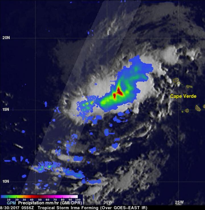
GPM scanned storms west of Irma's center of circulation and found rain dropping at rate of over 4.96 inches (126 mm) per hour where storm tops were reaching altitudes above 8.2 miles (13.2 km). Credits: NASA/JAXA, Hal Pierce
Tropical cyclones that form in that part of the Atlantic Ocean are often the largest and most powerful hurricanes of the season. Hurricanes Ivan (2004), Isabel (2003), Hugo (1989) and Allen (1980) are examples of past powerful hurricanes that formed near the Cape Verde islands.
The Global Precipitation Measurement mission or GPM core observatory satellite flew above forming tropical storm Irma on August 30, 2017 at 1:56 a.m. EDT (0556 UTC). This new tropical cyclone was forming from a tropical wave that was passing to the east of the Cape Verde islands.
Scans by GPM's Microwave Imager (GMI) and Dual-Frequency Precipitation
Radar (DPR) instruments (shown in lighter shades) revealed that heavy rain was falling in this area of strong convective storms. Rain falling at a rate of over 2.6 inches (66 mm) per hour was indicated by GPM's GMI.
DPR scanned storms to the west of the center of circulation and found rain dropping at rate of over 4.96 inches (126 mm) per hour. GPM's radar (DPR Ku band) showed that heights of convective storm tops located to the west of the forming tropical storm were reaching altitudes above 8.2 miles (13.2 km). GPM is a joint mission between NASA and the Japan Aerospace Exploration Agency, JAXA.
At 11 a.m. EDT (1500 UTC), the center of Tropical Storm Irma was located near 16.4 degrees north latitude and 30.3 degrees west longitude. That's about 420 miles (675 km) west of the Cabo Verde Islands. Irma was moving toward the west near 13 mph (20 kph) and this general motion is expected to continue for the next couple of days.
Satellite wind data indicate that the maximum sustained winds are near 50 mph (85 kph) with higher gusts. Some strengthening is forecast during the next 48 hours and Irma could become a hurricane on Friday, Sept.1.
Infrared image of Irma's western side confirmed the data from GPM. An infrared image was taken from the AIRS instrument aboard NASA's Aqua satellite on Aug. 30 at 11:53 a.m. EDT (1553 UTC). AIRS found powerful storms with very cold cloud top temperatures as cold as minus 63 degrees Fahrenheit (minus 53 degrees Celsius). Storms with cloud tops that cold extend high into the troposphere and have the ability to generate heavy rainfall.
The National Hurricane Center (NHC) indicates that Irma is moving toward the west-northwest. Irma is then expected to stay at low latitudes next week while approaching the Lesser Antilles.
###
For updated forecasts, visit: http://www.
By Hal Pierce/Rob Gutro
NASA's Goddard Space Flight Center
Media Contact
Media Contact
All latest news from the category: Earth Sciences
Earth Sciences (also referred to as Geosciences), which deals with basic issues surrounding our planet, plays a vital role in the area of energy and raw materials supply.
Earth Sciences comprises subjects such as geology, geography, geological informatics, paleontology, mineralogy, petrography, crystallography, geophysics, geodesy, glaciology, cartography, photogrammetry, meteorology and seismology, early-warning systems, earthquake research and polar research.


Newest articles

Bringing bio-inspired robots to life
Nebraska researcher Eric Markvicka gets NSF CAREER Award to pursue manufacture of novel materials for soft robotics and stretchable electronics. Engineers are increasingly eager to develop robots that mimic the…

Bella moths use poison to attract mates
Scientists are closer to finding out how. Pyrrolizidine alkaloids are as bitter and toxic as they are hard to pronounce. They’re produced by several different types of plants and are…

AI tool creates ‘synthetic’ images of cells
…for enhanced microscopy analysis. Observing individual cells through microscopes can reveal a range of important cell biological phenomena that frequently play a role in human diseases, but the process of…

