An interactive journey into the Earth system
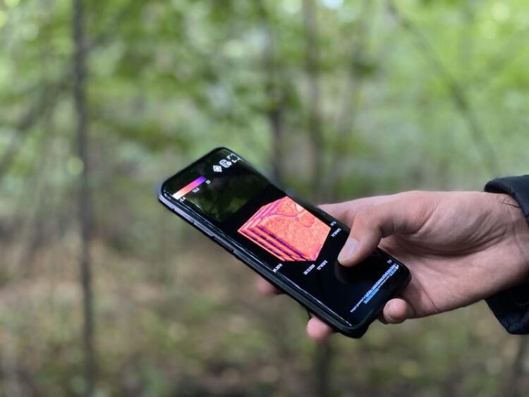
The LexCube is an interactive digital cube that can visualise climate data for any location and can even be accessed on a mobile phone.
(c) Anja Barz
Leipzig University presents LexCube 3D visualisation.
Researchers from Leipzig University will present an interactive digital cube that can visualise climate data from anywhere in the world in space and time at the Building Bridges for the Next Generations conference on 16 May. As a freely accessible website, LexCube makes terabytes of data available to everyone. The programming and implementation of the data cube is the PhD project of Maximilian Söchting, supervised by Professors Gerik Scheuermann and Miguel Mahecha.
Climate change and the biodiversity crisis are two of the greatest challenges facing society today. Leipzig University is conducting intensive and increasingly interdisciplinary research on both issues. One major challenge is dealing with vast amounts of data. An important step in understanding this data is the ability to present it visually, so that both researchers and anyone interested in the subject can quickly understand what information is hidden in, for example, climate models or satellite data.
Computer science and Earth system research join forces
Computer scientists and Earth system researchers at Leipzig University have developed a new tool for the interactive visualisation of large-scale climate and environmental data. LexCube processes a multitude of climate model data and satellite observations and presents them in a three-dimensional cube. Quite unlike conventional two-dimensional map views, LexCube now makes it possible to visualise time. “The time axis becomes an equal dimension to the spatial visualisation. This allows the viewer to quickly and intuitively understand, for example, how the temperature has changed in a particular location or across entire regions of the Earth,” says Maximilian Söchting, who is a doctoral researcher at the Remote Sensing Centre for Earth System Research (RSC4Earth) and Institute of Computer Science at Leipzig University. “LexCube can process extremely large amounts of data and can even be accessed on a mobile phone. And there are no access restrictions.”
Satellite data for climate and ecosystem change research
The data cube is based on existing open source technologies and will soon allow users to add their own data. For example, the current version of the LexCube displays the Earth System Data Cube, which was created by RSC4Earth and several partners under a grant from the European Space Agency (ESA). It integrates satellite data on the state of the world’s ecosystems, such as photosynthesis rates and soil moisture, as well as related meteorological conditions. Another dataset, funded by the Volkswagen Foundation, was created specifically for the Hainich national park and shows when the area’s predominant beech forest was particularly vital or, for example, damaged in the course of recent dry and hot years.
Powerful tool for scientists and policy makers
Together with his mentors, Professors Miguel Mahecha and Gerik Scheuermann, the 27-year-old has spent the past one and a half years developing and programming the interactive data cube. “In Earth system science, the LexCube will help us enormously to understand our basic data much better and to use it later for analysis, for example with the help of artificial intelligence. But I think the benefits go beyond science. Anyone interested can now take a quick look at spatio-temporal changes in the characteristics of our planet,” says Professor Miguel Mahecha, who has been working on the development of the Earth System Data Cube concept for many years. His colleague, computer scientist Professor Gerik Scheuermann adds: “Users can use the data cube to perform complex analyses and queries to gain insights from the data. We are already using the LexCube in university teaching.”
About the research project
The LexCube project originated as a pilot project within the German national research data infrastructure for Earth system sciences NFDI4Earth, in which Leipzig University plays a leading role. NFDI4Earth is funded by the German Research Foundation (DFG). But now the European Space Agency (ESA) has agreed to continue to support LexCube through the DeepESDL project, as there is evidence that it will benefit a very large user community. Scientifically, LexCube is a collaboration between RSC4Earth and the Image and Signal Processing Group of the Institute of Computer Science at Leipzig University.
Leipzig expertise at the Building Bridges conference
Professor Miguel Mahecha will present the LexCube at the Building Bridges for the Next Generations conference, which will take place in Dresden on 16 and 17 May in the presence of Minister President Michael Kretschmer, the Saxon Minister of Science Sebastian Gemkow, the Czech Prime Minister Petr Fiala and probably the Polish Prime Minister Mateusz Morawiecki. The aim is to promote scientific cooperation between the Czech Republic, Poland and Saxony and, in particular, to address a new generation of researchers on topical issues such as health, information technology, AI and climate change. Dr Zohreh Hosseinzadeh from Leipzig University’s Faculty of Medicine will also be on hand to talk about the future of functional retinal organoids.
Dr. Katarina Werneburg, Matthew Rockey
Contact for scientific information:
Prof. Dr. Miguel Mahecha
Institute for Geography
E-Mail: miguel.mahecha@uni-leipzig.de
Prof. Dr. Gerik Scheuermann
Institute of Computer Science
Telefon: +49 341 97-32251
E-Mail: scheuermann@informatik.uni-leipzig.de
Web: http://www.informatik.uni-leipzig.de
Maximilian Söchting
E-Mail: maximilian.soechting@uni-leipzig.de
More information:
https://building-bridges-conference.eu/
https://www.lexcube.org/?!esdc-2.1.1-high-res/air_temperature_2m/48-1836/0-2156/…
Media Contact
All latest news from the category: Earth Sciences
Earth Sciences (also referred to as Geosciences), which deals with basic issues surrounding our planet, plays a vital role in the area of energy and raw materials supply.
Earth Sciences comprises subjects such as geology, geography, geological informatics, paleontology, mineralogy, petrography, crystallography, geophysics, geodesy, glaciology, cartography, photogrammetry, meteorology and seismology, early-warning systems, earthquake research and polar research.


Newest articles

Bringing bio-inspired robots to life
Nebraska researcher Eric Markvicka gets NSF CAREER Award to pursue manufacture of novel materials for soft robotics and stretchable electronics. Engineers are increasingly eager to develop robots that mimic the…

Bella moths use poison to attract mates
Scientists are closer to finding out how. Pyrrolizidine alkaloids are as bitter and toxic as they are hard to pronounce. They’re produced by several different types of plants and are…

AI tool creates ‘synthetic’ images of cells
…for enhanced microscopy analysis. Observing individual cells through microscopes can reveal a range of important cell biological phenomena that frequently play a role in human diseases, but the process of…

