NASA and other satellites keeping busy with this week's severe weather
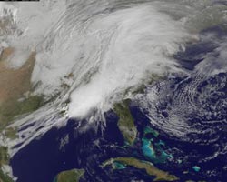
On March 9 at 1445 UTC (10:45 a.m. EST), the GOES-13 satellite captured a visible image of the massive storm system that covers about one-third of the US. Credit: NOAA/NASA GOES Project<br>
Today the eastern third of the U.S. is being buffered by a large storm that stretches from southeastern Minnesota east to Wisconsin and Michigan, then south through the Ohio Valley and all the way down to eastern Louisiana. That massive storm system was captured in an image by the Geostationary Operational Environmental Satellite called GOES-13.
GOES satellites are operated by the National Oceanic and Atmospheric Administration, and NASA's GOES Project, located at NASA's Goddard Space Flight Center, Greenbelt, Md. creates some of the GOES satellite images and animations.
Dennis Chesters, a GOES Project scientist at NASA Goddard, noted “The wide angle view provided by GOES reveals that the on-shore flow from the Gulf is part of a much larger oceanic circulation centered east of the Bahamas. That is driving a nearly unlimited supply of warm moisture over the eastern U.S. from as far south as Jamaica. With all that energy to work with, the wall of condensation and rainfall at the front pushed convective towers up to the stratosphere, which cast long shadows into the dawn behind the storm.”
Flooding is already occurring in various areas around the eastern third of the U.S. NOAA's National Weather Service Hydrometeorological Prediction Center (HPC), the organization that monitors flooding, noted that flooding is already occurring in west-central Illinois, and along the Illinois/Kentucky border area of the Ohio River. Flooding has also been on-going this past week in Indiana. Heavy rains had previously flooded roads and raised levels of creeks and rivers across the state. This system is expected to bring up to a quarter of an inch more rain to the soggy state, maybe mixed with some snow near Indianapolis tonight. For more information about flooding maps and potential flood areas, go to the NOAA HPC website: http://www.hpc.ncep.noaa.gov/nationalfloodoutlook/index.html.
The storm is forecast by the National Weather Service (NWS) to move eastward by Thursday and affect the central Appalachian Mountains and U.S. east coast bringing heavy rainfall. The rainfall potentials will be high because the system is expected to pull moisture northward from the Gulf of Mexico up into the Ohio Valley. As the storm system progresses, more moisture will feed in from the Atlantic Ocean over the east coast.
NASA's Aqua satellite captured another view of the massive storm system today, March 9 at 07:59 UTC (2:59 a.m. EST) that revealed deep convection (rapidly rising air that forms thunderstorms) and cold cloud top temperatures in the southern part of the system.
Cloud temperatures are a key in determining storm strength. The higher the cloud tops are, the stronger the convection and the stronger the thunderstorms are. That's why infrared data from AIRS is so important to forecasters. AIRS data showed that most of the coldest, highest cloud tops and strongest thunderstorms (and heaviest rainfall) were over eastern Louisiana, Mississippi and Alabama this morning, and those cloud-tops were as cold as or colder than -63 Fahrenheit (-52 Celsius).
The northernmost part of the storm is expected to bring light snows, freezing rain and rain to some areas of the upper Midwest and east to northern New England on Thursday. Further south, light to moderate rains are expected over the Ohio and Tennessee Valleys today, that will move northeast tomorrow.
The New York metro area is expecting between 1 and 3 inches of rain as the front creeps eastward and a series of low pressure waves develop along it. Flooding of rivers, small streams and poorly drained areas will be possible. Further north in Albany, N.Y. snow is expected to mix into the rain.
In the Mid-Atlantic, heavy rains are possible from this slow moving low pressure area and associated cold front. The same area received heavy rain just four days before on Sunday. Today, the National Weather Service in Washington, D.C. has posted flood watches and coastal flood watches. The Nation's Capital may receive up to three inches of rain before the storm passes late Thursday. Farther south in Norfolk, Va. 1 to 2 inches of rainfall are expected, and south central and southeast Virginia along with northeast North Carolina may get strong to severe thunderstorms on Thursday.
The central Gulf coast and southeastern U.S. are expected to see showers and thunderstorms from the front, and there's a slight risk of severe thunderstorms in that region Wednesday and Thursday. The NWS in Savannah, Ga. forecast says “a few of the storms may become severe with damaging wind gusts and possibly isolated tornadoes between midnight tonight (Wednesday) and dawn on Thursday along and to the west of Interstate 95.”
Farther south in Florida, Jacksonville is going to see an interaction of that approaching cold front with strong high pressure to the north that will kick up winds from the south to the southeast today, gusting to 35 mph, so a lake wind advisory was issued today from the local NWS. There's also a moderate risk of rip currents at the beaches. Even before the front gets there, a pre-frontal squall line is forecast to cross the Gulf Coast region today, and the NWS says there is a potential for strong or possibly severe thunderstorms to impact interior southeast Georgia and the northern Suwannee River Valley in Northeast Florida.
This past weekend, NASA's Tropical Rainfall Measuring Mission (TRMM) satellite was flying in space when it passed over tornadoes occurring in the state of Louisiana on March 5 at 1411 UTC (8:11 a.m. CST). The National Oceanic and Atmospheric Administration (NOAA) reported that seven tornadoes were spotted in Louisiana on that date. Those tornadoes caused at least 15 injuries and one death when a tornado hit in the northwest section of Rayne, Louisiana.
TRMM captured rainfall rates of the tornadic thunderstorms from March 5, 2011 when the system generated tornadoes in Louisiana. TRMM's Microwave Imager and Precipitation Radar showed that extremely heavy rainfall was falling from those storms at a rate of more than 2 inches (50 mm) per hour. Surrounding the intense rainfall areas were areas of moderate rainfall between .78 to 1.57 inches (20 to 4 mm) per hour.
Another view of the storm looking from the east was created by the TRMM Team at NASA Goddard. Using TRMM Precipitation Radar data, Hal Pierce of the NASA TRMM team created a 3-D image that sliced through the storm. The 3-D image showed that one of those powerful tornadic thunderstorms had intense echoes reaching as high as 9.3 miles (15km).
TRMM images are pretty complicated to create. At NASA Goddard, rain rate data from the TRMM Precipitation Radar (PR) instrument are taken from the center of the swath (the satellite's orbit path over the storm). The rain rates in the outer portion of the storm are created from a different instrument on the satellite, called the TRMM Microwave Imager (TMI). The rain rates are then overlaid on infrared (IR) data from the TRMM Visible Infrared Scanner (VIRS). The TRMM satellite is managed by NASA and the Japanese Space Agency, JAXA. For more information about TRMM, visit: http://www.trmm.gsfc.nasa.gov/.
The GOES-13 satellite continues to provide updated imagery on the NASA GOES Project website at http://goes.gsfc.nasa.gov/, so if you want to see when sunshine and a clear sky will return, look to the left (west) of the cloud cover on GOES images.
Media Contact
All latest news from the category: Information Technology
Here you can find a summary of innovations in the fields of information and data processing and up-to-date developments on IT equipment and hardware.
This area covers topics such as IT services, IT architectures, IT management and telecommunications.


Newest articles

“Nanostitches” enable lighter and tougher composite materials
In research that may lead to next-generation airplanes and spacecraft, MIT engineers used carbon nanotubes to prevent cracking in multilayered composites. To save on fuel and reduce aircraft emissions, engineers…

Trash to treasure
Researchers turn metal waste into catalyst for hydrogen. Scientists have found a way to transform metal waste into a highly efficient catalyst to make hydrogen from water, a discovery that…

Real-time detection of infectious disease viruses
… by searching for molecular fingerprinting. A research team consisting of Professor Kyoung-Duck Park and Taeyoung Moon and Huitae Joo, PhD candidates, from the Department of Physics at Pohang University…

