Using drones to estimate crop damage by wild boars
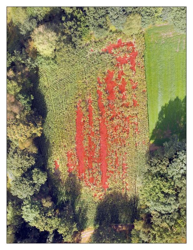
Combined photograph of a maize field. The red areas are the damaged parts of the field, detected by an algorithm. Image: Anneleen Rutten
Anneleen Rutten, PhD student at the University of Antwerp and the Research Institute for Nature and Forest (INBO, Brussels) will present the method at the ‘Ecology Across Borders’ conference in Ghent, Belgium this week. She uses a standard commercial drone to take aerial photographs of agricultural fields, which are analysed with an algorithm to identify the damaged areas.
Rising numbers of wild boar have been linked to higher crop damage, disease transmissions and car accidents in many European countries. In Flanders, wild boars have been absent for almost 50 years and only returned in 2006. Estimates from hunting bags show a growing population which is still expanding its range, from the Eastern province of Limburg towards the more central provinces of Antwerp and Vlaams-Brabant.
Landscape structures in Flanders changed in the years of absence of wild boar, resulting in a dense, mosaic-like pattern of agricultural, natural and urban areas. Thus, there have been many human-wildlife conflicts in the last years.
“I want to get a first insight into the extent of agricultural damage by wild boars because, in contrast to neighbouring regions and countries, this has not been monitored in the past and it is not known how high the financial damages are for this sector”, Anneleen Rutten says.
The method was developed to be affordable and easy to apply. “I connect my smartphone to the remote controller of my drone which allows me to see the camera visualisation. Damage is really clear on the camera: in maize fields, boars roll over the maize which results in gaping holes with broken stems in an otherwise green field. In grasslands, rooting causes a clear colour difference because the soil is rooted up”, Rutten explains.
For each field, many individual photographs with 75-85% overlap are taken. The high overlap enables combination of individual photographs into a single image, taking account of different perspectives and showing the entire field. The area of the field is then classified into damaged and undamaged parts using Object Based Image Analysis (OBIA). The algorithm reaches 93% of accuracy for maize fields and 94% for grasslands.
Traditionally, crop damage is estimated by trained experts measuring the damaged area in the field. “Flying and taking photographs of damaged fields does not take as long as doing an assessment by ground visits, making it more cost-effective”, Rutten adds. Another advantage is that the method is standardised allowing for direct comparisons between different fields and over time.
Anneleen Rutten will present her work at the conference ‘Ecology Across Borders’ on Tuesday, 12 December 2017.
This year’s annual meeting is jointly organised by the British Ecological Society, Gesellschaft für Ökologie (the Ecological Society of Germany, Switzerland and Austria), and Dutch-Flemish Ecological Society (NecoV), in association with the European Ecological Federation, bringing together 1,500 ecologists from around 60 countries to discuss the latest advances in ecological research across the whole discipline.
http://www.britishecologicalsociety.org/events/annual-meeting-2017/
https://eventmobi.com/eab2017/
Media Contact
All latest news from the category: Ecology, The Environment and Conservation
This complex theme deals primarily with interactions between organisms and the environmental factors that impact them, but to a greater extent between individual inanimate environmental factors.
innovations-report offers informative reports and articles on topics such as climate protection, landscape conservation, ecological systems, wildlife and nature parks and ecosystem efficiency and balance.


Newest articles

Properties of new materials for microchips
… can now be measured well. Reseachers of Delft University of Technology demonstrated measuring performance properties of ultrathin silicon membranes. Making ever smaller and more powerful chips requires new ultrathin…

Floating solar’s potential
… to support sustainable development by addressing climate, water, and energy goals holistically. A new study published this week in Nature Energy raises the potential for floating solar photovoltaics (FPV)…

Skyrmions move at record speeds
… a step towards the computing of the future. An international research team led by scientists from the CNRS1 has discovered that the magnetic nanobubbles2 known as skyrmions can be…

