Flooding in Suriname: International Charter activated
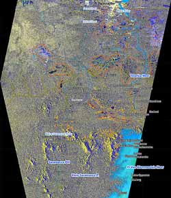
Suriname has been affected by severe flooding caused by torrential rains since 1 May 2006. This map , over the area south of Paramaribo to Pr. Van Blommestein Meer, was developed in response to the International Charter "Space and Major Disasters" being activated and shows potentially affected flooded areas as derived from satellite imagery (Envisat, Landsat, Spot 5). (Copyrights - Analysis of user requirements by UNOSAT; Spot data: CNES; Envisat data: ESA; LANDSAT data: USGS & Maryland GLCF; VMAP data: NGA) Credits: SERTIT 2006
At least three people have been killed and an estimated 25 000 people have been displaced in Suriname as a result of flooding caused by torrential rains since 1 May. Approximately 25 000-30 000 square kilometres are currently under water, and the government has declared the southwest and central lowlands disaster zones.
In response to the crisis, the U.N. Office for the Coordination of Humanitarian Affairs (OCHA) has called for helicopters to deliver relief supplies. According to media reports, a Dutch relief plane flew blankets, stretchers, tarpaulins and mosquito nets to the area on Monday. The Suriname military is also reported to have been distributing food packages and hygienic items.
According to OCHA, an increase in the number of respiratory infections has been reported and stored rainwater, used for drinking, is quickly diminishing. Malaria is also a growing concern as it is endemic in the interior of Suriname.
In order to observe the crisis, the U.N. Office for Outer Space Affairs (UNOOSA) requested maps of the area from the International Charter “Space and Major Disasters”. This map, over the area south of Paramaribo to Pr. Van Blommestein Meer, was comprised of ESA Envisat satellite imagery and complemented by SPOT5 satellite data. The data covering water bodies were derived from NASA’s Landsat 7 satellite.
Areas outlined in red and orange are potentially affected flooded areas as derived from Envisat, using its Advanced Synthetic Aperture Radar (ASAR) instrument, and Spot 5 respectively. The actual image, in which the vector information is overlain, is a multitemporal Envisat ASAR image composed of two images: one acquired on 1 October 2004 and another on 14 May 2006.
Media Contact
More Information:
http://www.esa.int/esaEO/SEMRZA9ATME_environment_0.htmlAll latest news from the category: Ecology, The Environment and Conservation
This complex theme deals primarily with interactions between organisms and the environmental factors that impact them, but to a greater extent between individual inanimate environmental factors.
innovations-report offers informative reports and articles on topics such as climate protection, landscape conservation, ecological systems, wildlife and nature parks and ecosystem efficiency and balance.


Newest articles

Properties of new materials for microchips
… can now be measured well. Reseachers of Delft University of Technology demonstrated measuring performance properties of ultrathin silicon membranes. Making ever smaller and more powerful chips requires new ultrathin…

Floating solar’s potential
… to support sustainable development by addressing climate, water, and energy goals holistically. A new study published this week in Nature Energy raises the potential for floating solar photovoltaics (FPV)…

Skyrmions move at record speeds
… a step towards the computing of the future. An international research team led by scientists from the CNRS1 has discovered that the magnetic nanobubbles2 known as skyrmions can be…

