Western Indian Ocean earthquake and tsunami hazard potential greater than previously thought
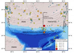
The location of the Makran subduction zone of Pakistan and Iran and locations of recorded earthquakes including the 1945 magnitude 8.1 earthquake (red dot to the north indicates the 1947 magnitude 7.3 earthquake). The profile for the thermal modelling of this study is the N-S trending black line, with distance given along the profile from the shallowest part of the subduction zone in the south (0 kilometers) to the most northern potential earthquake rupture extent (350 kilometers).<br><br>Credit: University of Southampton Ocean and Earth Science<br>
The research was carried out by scientists from the University of Southampton based at the National Oceanography Centre Southampton (NOCS), and the Pacific Geoscience Centre, Natural Resources Canada.
The study suggests that the risk from undersea earthquakes and associated tsunami in this area of the Western Indian Ocean – which could threaten the coastlines of Pakistan, Iran, Oman, India and potentially further afield – has been previously underestimated. The results highlight the need for further investigation of pre-historic earthquakes and should be fed into hazard assessment and planning for the region.
Subduction zones are areas where two of the Earth's tectonic plates collide and one is pushed beneath the other. When an earthquake occurs here, the seabed moves horizontally and vertically as the pressure is released, displacing large volumes of water that can result in a tsunami.
The Makran subduction zone has shown little earthquake activity since a magnitude 8.1 earthquake in 1945 and magnitude 7.3 in 1947. Because of its relatively low seismicity and limited recorded historic earthquakes it has often been considered incapable of generating major earthquakes.
Plate boundary faults at subduction zones are expected to be prone to rupture generating earthquakes at temperatures of between 150 and 450 °C. The scientists used this relationship to map out the area of the potential fault rupture zone beneath the Makran by calculating the temperatures where the plates meet. Larger fault rupture zones result in larger magnitude earthquakes.
“Thermal modelling suggests that the potential earthquake rupture zone extends a long way northward, to a width of up to 350 kilometres which is unusually wide relative to most other subduction zones,” says Gemma Smith, lead author and PhD student at University of Southampton School of Ocean and Earth Science, which is based at NOCS.
The team also found that the thickness of the sediment on the subducting plate could be a contributing factor to the magnitude of an earthquake and tsunami there.
“If the sediments between the plates are too weak then they might not be strong enough to allow the strain between the two plates to build up,” says Smith. “But here we see much thicker sediments than usual, which means the deeper sediments will be more compressed and warmer. The heat and pressure make the sediments stronger. This results in the shallowest part of the subduction zone fault being potentially capable of slipping during an earthquake.
“These combined factors mean the Makran subduction zone is potentially capable of producing major earthquakes, up to magnitude 8.7-9.2. Past assumptions may have significantly underestimated the earthquake and tsunami hazard in this region.”
Notes for editors
1. Reference: Smith, G.L., McNeill, L.C., Wang, K., He, J., and Henstock, T.J., 2013, Thermal structure and megathrust seismogenic potential of the Makran subduction zone: Geophys. Res. Lett., 40, doi:10.1002/grl.50374.
2. Gemma Smith is a PhD student at the Graduate School of the National Oceanography Centre Southampton (GSNOCS).
3. Image 1 shows the location of the Makran subduction zone of Pakistan and Iran and locations of recorded earthquakes including the 1945 magnitude 8.1 earthquake (red dot to the north indicates the 1947 magnitude 7.3 earthquake). The profile for the thermal modelling of this study is the north-south trending black line, with distance given along the profile from the shallowest part of the subduction zone in the south (0 kilometres) to the most northern potential earthquake rupture extent (350 kilometres).
4. Image 2 shows the primary tectonic plates and plate boundaries in the Arabian Sea region and the geographic context.
5. The University of Southampton is a leading UK teaching and research institution with a global reputation for leading-edge research and scholarship across a wide range of subjects in engineering, science, social sciences, health and humanities.
http://www.southampton.ac.uk
6. The National Oceanography Centre (NOC) is the UK's leading institution for integrated coastal and deep ocean research. NOC operates the Royal Research Ships James Cook and Discovery and develops technology for coastal and deep ocean research. Working with its partners NOC provides long-term marine science capability including: sustained ocean observing, mapping and surveying, data management and scientific advice.
NOC operates at two sites, Southampton and Liverpool, with the headquarters based in Southampton. The centre is wholly owned by the Natural Environment Research Council (NERC).
http://www.noc.ac.uk
Contact details
Catherine Beswick, Communications and Public Engagement, National Oceanography Centre, catherine.beswick@noc.ac.uk, +44 238 059 8490
Media Contact
All latest news from the category: Earth Sciences
Earth Sciences (also referred to as Geosciences), which deals with basic issues surrounding our planet, plays a vital role in the area of energy and raw materials supply.
Earth Sciences comprises subjects such as geology, geography, geological informatics, paleontology, mineralogy, petrography, crystallography, geophysics, geodesy, glaciology, cartography, photogrammetry, meteorology and seismology, early-warning systems, earthquake research and polar research.


Newest articles

Properties of new materials for microchips
… can now be measured well. Reseachers of Delft University of Technology demonstrated measuring performance properties of ultrathin silicon membranes. Making ever smaller and more powerful chips requires new ultrathin…

Floating solar’s potential
… to support sustainable development by addressing climate, water, and energy goals holistically. A new study published this week in Nature Energy raises the potential for floating solar photovoltaics (FPV)…

Skyrmions move at record speeds
… a step towards the computing of the future. An international research team led by scientists from the CNRS1 has discovered that the magnetic nanobubbles2 known as skyrmions can be…

