Tropical Storm Richard born in the Caribbean, GOES-13, TRMM watching
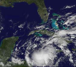
This visible GOES-13 image of Tropical Storm Richard at 1732 UTC (1:32 p.m. EDT) on Oct. 22 shows that Richard\'s clouds already over the Honduras/Nicaragua border as it heads toward Belize for landfall this weekend.<br>Credit: NOAA/NASA GOES Project<br>
The Geostationary Operational Environmental Satellite called GOES-13 captured a visible image of Tropical Storm Richard at 1732 UTC (1:32 p.m. EDT) on Oct. 22. GOES satellites are managed by NOAA. NASA's GOES Project at NASA's Goddard Space Flight Center in Greenbelt, Md. creates images and animations from the satellite data and created today's image that shows Richard's clouds are already over the Honduras/Nicaragua border as it heads toward Belize for landfall this weekend.
Watches and warnings are already in effect as residents are bracing for Richard's arrival as a hurricane. A hurricane watch is in effect for Honduras from the Nicaragua/Honduras Border westward to Limon, and a tropical storm warning is in effect for Honduras from the Nicaragua/Honduras Border westward to Limon.
At 2 p.m. EDT on Oct. 22, Richard was still a tropical storm with maximum sustained winds near 40 mph, but he is expected to intensify in the warm waters of the western Caribbean before he makes landfall. Richard's center is located about 140 miles east-northeast of Cabo Gracias a Dios on the Nicaragua/Honduras border, near 15.8 North and 81.3 West. It is moving west at 3 mph and has a minimum central pressure of 1006 millibars.
Richard is expected to be a big rainmaker, with maximum storm totals between 5 and 7 inches. With this amount of rain, flash flooding and mudslides are possible. Winds will pick up as Richard continues its slow crawl to land. Northeastern Honduras can expect tropical storm conditions late Saturday.
Media Contact
More Information:
http://www.nasa.govAll latest news from the category: Earth Sciences
Earth Sciences (also referred to as Geosciences), which deals with basic issues surrounding our planet, plays a vital role in the area of energy and raw materials supply.
Earth Sciences comprises subjects such as geology, geography, geological informatics, paleontology, mineralogy, petrography, crystallography, geophysics, geodesy, glaciology, cartography, photogrammetry, meteorology and seismology, early-warning systems, earthquake research and polar research.


Newest articles

Bringing bio-inspired robots to life
Nebraska researcher Eric Markvicka gets NSF CAREER Award to pursue manufacture of novel materials for soft robotics and stretchable electronics. Engineers are increasingly eager to develop robots that mimic the…

Bella moths use poison to attract mates
Scientists are closer to finding out how. Pyrrolizidine alkaloids are as bitter and toxic as they are hard to pronounce. They’re produced by several different types of plants and are…

AI tool creates ‘synthetic’ images of cells
…for enhanced microscopy analysis. Observing individual cells through microscopes can reveal a range of important cell biological phenomena that frequently play a role in human diseases, but the process of…

