Tropical Storm Priscilla's Short Life
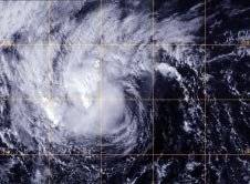
A GOES-West satellite visible image of post-tropical storm Priscilla on Oct. 15 at 2215 UTC/6:15 p.m. EDT showed the bulk of precipitation west of the center from wind shear. <br>Image Credit: NRL/NOAA<br>
Priscilla skipped the depression phase and went from a low pressure area to a full-blown tropical storm at 5 a.m. EDT/0900 UTC on Oct. 14. Priscilla formed near 14.3 north and 115.7 west, about 705 miles/1,135 km southwest of the southern tip of Baja California. Priscilla moved north-northeast and had maximum sustained winds near 40 mph/65 kph at birth.
On Oct. 15 Priscilla had already weakened to a depression because of wind shear and the arrival of more stable air into the environment around the tropical storm.
At 5 p.m. EDT/2100 UTC, Priscilla's maximum sustained winds dropped to 35 mph/55 kph. The center of tropical depression Priscilla was located near latitude 17.7 north and longitude 117.5, about 610 miles/980 km southwest of the southern tip of Baja California
Priscilla was moving toward the west-northwest near 8 mph/13 kph and this general motion is expected to continue through Oct. 16.
A GOES-West satellite visible image on Oct. 15 at 2215 UTC/6:15 p.m. EDT that showed the bulk of precipitation west of the center from wind shear.
By Oct. 17, Priscilla was a post-tropical cyclone. The last bulletin issued by the National Hurricane Center pinpointed the center near 18.7 north and 120.9 west, about 765 miles west-southwest of Cabo San Lucas, Mexico. The post-tropical cyclone was fading fast as sustained winds dropped to 25 knots/28.7 mph/46.3 kph. The National Hurricane Center noted at 0300 UTC on Oct. 17/11 p.m. EDT Oct. 16, that Priscilla ceased to qualify as a tropical cyclone.
Text credit: Rob Gutro
NASA's Goddard Space Flight Center
Media Contact
All latest news from the category: Earth Sciences
Earth Sciences (also referred to as Geosciences), which deals with basic issues surrounding our planet, plays a vital role in the area of energy and raw materials supply.
Earth Sciences comprises subjects such as geology, geography, geological informatics, paleontology, mineralogy, petrography, crystallography, geophysics, geodesy, glaciology, cartography, photogrammetry, meteorology and seismology, early-warning systems, earthquake research and polar research.


Newest articles

Silicon Carbide Innovation Alliance to drive industrial-scale semiconductor work
Known for its ability to withstand extreme environments and high voltages, silicon carbide (SiC) is a semiconducting material made up of silicon and carbon atoms arranged into crystals that is…

New SPECT/CT technique shows impressive biomarker identification
…offers increased access for prostate cancer patients. A novel SPECT/CT acquisition method can accurately detect radiopharmaceutical biodistribution in a convenient manner for prostate cancer patients, opening the door for more…

How 3D printers can give robots a soft touch
Soft skin coverings and touch sensors have emerged as a promising feature for robots that are both safer and more intuitive for human interaction, but they are expensive and difficult…

