Tropical Storm Octave makes landfall in western Mexico
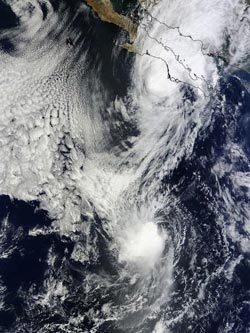
This MODIS image from NASA's Terra satellite shows Tropical Storm Octave in the Gulf of California and Tropical Storm Priscilla in the open waters of the Eastern Pacific. The image was taken on Oct. 14 at 2:40 p.m. EDT.<br><br>Credit: Image Credit: NASA Goddard MODIS Rapid Response Team<br>
TD15-E formed about 470 miles/755 km south of the southern tip of Baja California, near 16.1 north and 110.2 west. By 5 a.m. EDT on Oct. 13, TD15-E became Tropical Storm Octave. Octave's maximum sustained winds peaked at 65 mph/100 kph at 11 p.m. EDT on Oct. 13 when it was about 215 miles/345 km northwest of Socorro Island, near 20.6 north and 113.7 west.
The Moderate Resolution Imaging Spectroradiometer aboard NASA's Terra satellite saw Tropical Storm Octave in the Gulf of California and Tropical Storm Priscilla in the open waters of the Eastern Pacific on Oct. 14 at 2:40 p.m. EDT.
By 5 p.m. EDT/2100 UTC on Oct. 15, Octave had become a post-tropical cyclone. It was located near latitude 26.9 north and longitude 109.4 west in the Gulf of California, about 80 miles/130 km north-northwest of Los Mochis, Mexico. Maximum sustained winds decreased to near 25 mph/35 kph.
The post-tropical cyclone was moving toward the north-northeast near 5 mph/7 kph and that general motion continued until the system moved over mainland Mexico between Guaymas and Los Mochis. Although Octave dissipated on Oct. 16 the remnants brought large rainfall totals to mainland Mexico, between 3 to 6 inches over the state of Sonora.
Text credit: Rob Gutro
NASA's Goddard Space Flight Center
Media Contact
More Information:
http://www.nasa.govAll latest news from the category: Earth Sciences
Earth Sciences (also referred to as Geosciences), which deals with basic issues surrounding our planet, plays a vital role in the area of energy and raw materials supply.
Earth Sciences comprises subjects such as geology, geography, geological informatics, paleontology, mineralogy, petrography, crystallography, geophysics, geodesy, glaciology, cartography, photogrammetry, meteorology and seismology, early-warning systems, earthquake research and polar research.


Newest articles

Properties of new materials for microchips
… can now be measured well. Reseachers of Delft University of Technology demonstrated measuring performance properties of ultrathin silicon membranes. Making ever smaller and more powerful chips requires new ultrathin…

Floating solar’s potential
… to support sustainable development by addressing climate, water, and energy goals holistically. A new study published this week in Nature Energy raises the potential for floating solar photovoltaics (FPV)…

Skyrmions move at record speeds
… a step towards the computing of the future. An international research team led by scientists from the CNRS1 has discovered that the magnetic nanobubbles2 known as skyrmions can be…

