Tropical Depression Dokuri weaker, but still potent
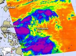
NASA's Aqua satellite passed over Tropical Storm Dokuri on June 27 on 0435 UTC (12:35 a.m. EDT). Infrared data from the AIRS instrument onboard, indicated the there were still some strong (purple) showers and thunderstorms within. Credit: Credit: NASA/JPL, Ed Olsen<br>
NASA's Aqua satellite passed over Tropical Storm Dokuri on June 27 on 0435 UTC (12:35 a.m. EDT). Infrared data from the Atmospheric Infrared Sounder (AIRS) instrument onboard indicated there were still some strong showers and thunderstorms within the system. Those cloud top temperatures were colder than -63 Fahrenheit (-52 Celsius), indicating strong uplift in the atmopshere, and thunderstorms within Dokuri that have the capability for heavy rainfall.
Infrared data shows a fully-exposed low level-circulation center. The strongest convection (rising air that creates thunderstorms that make up the system)are being pushed to the southwest due to strong northeasterly vertical wind shear.
Warnings are up in the Philippines as Doksuri (known there as Dindo) continues to move north of Luzon today. Public storm warning signal #1 is in effect in Abra, Kalinga, Isabela, Ilocos Sur, Mt. Province, Ifugao, La Union, Benguet, Pangasinan, Nueva Vizcaya and Quirino. Public storm warning signal #2 is also in effect for Cagayan, Calayan Group of Islands, Babuyan Group of Islands, Batanes Group of Islands, Apayao, Ilocos Norte.
On June 28, 2012 at 1500 UTC (11 a.m. EDT), Tropical Storm Doksuri had maximum sustained winds near 35 knots. It was located approximately 335 nautical miles north of Manila, Philippines, near 20.4 North and 120.7 East. It was moving to the west-northwestward at 17 knots. The strongest convection and thunderstorms were located over northern Luzon at this time, and are moving off the northwestern coast of the Philippines.
Doksuri has weakened as it passes to the north of Luzon. Doksuri is expected to continue tracking west and make landfall near Hong Kong in two days.
Media Contact
More Information:
http://www.nasa.govAll latest news from the category: Earth Sciences
Earth Sciences (also referred to as Geosciences), which deals with basic issues surrounding our planet, plays a vital role in the area of energy and raw materials supply.
Earth Sciences comprises subjects such as geology, geography, geological informatics, paleontology, mineralogy, petrography, crystallography, geophysics, geodesy, glaciology, cartography, photogrammetry, meteorology and seismology, early-warning systems, earthquake research and polar research.


Newest articles

Machine learning algorithm reveals long-theorized glass phase in crystal
Scientists have found evidence of an elusive, glassy phase of matter that emerges when a crystal’s perfect internal pattern is disrupted. X-ray technology and machine learning converge to shed light…

Mapping plant functional diversity from space
HKU ecologists revolutionize ecosystem monitoring with novel field-satellite integration. An international team of researchers, led by Professor Jin WU from the School of Biological Sciences at The University of Hong…

Inverters with constant full load capability
…enable an increase in the performance of electric drives. Overheating components significantly limit the performance of drivetrains in electric vehicles. Inverters in particular are subject to a high thermal load,…

