Tropical Depression 10W bringing rain to the Philippines
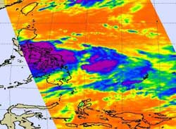
This infrared image of Tropical Depression 10W was taken from the AIRS instrument on NASA's Aqua satellite on July 25 at 0441 UTC (12:41 a.m. EDT) and it revealed a large area of very cold cloud top temperatures (purple) from strong thunderstorms over the central Philippines. Credit: NASA JPL, Ed Olsen<br>
When NASA's Aqua satellite passed over Tropical Depression 10W on July 25 at 0441 UTC (12:41 a.m. EDT), the infrared image captured by the Atmospheric Infrared Sounder (AIRS) instrument revealed a large area of very cold cloud top temperatures (-63F/-52C) from strong thunderstorms over the central Philippines. A second area of strong thunderstorms on the eastern side of circulation was over the Philippine Sea.
On July 25 at 0600 UTC (2 a.m. EDT) Tropical Depression 10W's maximum sustained winds were near 30 knots (34 mph/55 kmh). It was about 335 nautical miles (385 miles/ 620 km) east of Manila, Philippines near 13.8 North and 126.4 East. Tropical Depression 10W (TD10W) is moving to the northwest at 9 knots (10 mph/17 kmh).
Satellite imagery has shown that the bands of thunderstorms feeding into the center of TD10W's circulation. TD10W continues to become more organized. The system is in an area of low to moderate wind shear which is enabling it to become better organized.
At 11 a.m. EDT on July 25, a weather station in Daet, Philippines was reporting thunderstorms and rain, with winds from the west at 11 mph. Daet is the capital municipality in the Camarines Norte province. The local forecast calls for TD10W to affect the city through the day on July 26.
The Joint Typhoon Warning Center forecasters expect TD10W to slowly intensify over the next two days and make landfall northeast of Hong Kong later this week.
Media Contact
More Information:
http://www.nasa.govAll latest news from the category: Earth Sciences
Earth Sciences (also referred to as Geosciences), which deals with basic issues surrounding our planet, plays a vital role in the area of energy and raw materials supply.
Earth Sciences comprises subjects such as geology, geography, geological informatics, paleontology, mineralogy, petrography, crystallography, geophysics, geodesy, glaciology, cartography, photogrammetry, meteorology and seismology, early-warning systems, earthquake research and polar research.


Newest articles

High-energy-density aqueous battery based on halogen multi-electron transfer
Traditional non-aqueous lithium-ion batteries have a high energy density, but their safety is compromised due to the flammable organic electrolytes they utilize. Aqueous batteries use water as the solvent for…

First-ever combined heart pump and pig kidney transplant
…gives new hope to patient with terminal illness. Surgeons at NYU Langone Health performed the first-ever combined mechanical heart pump and gene-edited pig kidney transplant surgery in a 54-year-old woman…

Biophysics: Testing how well biomarkers work
LMU researchers have developed a method to determine how reliably target proteins can be labeled using super-resolution fluorescence microscopy. Modern microscopy techniques make it possible to examine the inner workings…

