Tropical Cyclone Helen headed for landfall in India
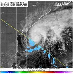
Visible/short wave infrared data from ESA's METEO-7 satellite and rainfall data from NASA's TRMM satellite was combined to create this image of Tropical Cyclone Helen on Nov. 20.<br><br>Credit: NRL/NASA/ESA<br>
On Nov. 20 at 1200 UTC/7 a.m. EST, Tropical Cyclone Helen had maximum sustained winds near 50 knots/57.5 mph/92.6 kph. It was centered near 15.5 north and 83.9 east, about 499 nautical miles/574.2 miles/924.1 km south-southwest of Calcutta, India. Helen was crawling to the northwest at 1 knot/1.1 mph/1.8 kph. A mid-level subtropical ridge (elongated area) of high pressure is expected to slowly build east of Helen and steer the storm on a more western track in the next day.
Current warnings are in effect for fishermen along the coasts of Andhra Pradesh, who are advised to return to shore.
Animated multispectral satellite showed a resurgence of deep convection over the low-level center of circulation. Satellite data also showed that the band of thunderstorms that appeared strong to the north has weakened and become fragmented. Visible/short wave infrared data from ESA's METEO-7 satellite and rainfall data from NASA's Tropical Rainfall Measuring Mission or TRMM satellite was combined at the Naval Research Laboratory to create a composite image of the storm on Nov. 20. The image showed the clouds associated with Helen were mostly still over the open waters of the Arabian Sea, and that south of the center, light rainfall was occurring.
Helen is expected to intensify to 60 knots/69.0 mph/111.1 kph over the next two days and weaken before landfall. Helen is forecast to pass just south of the Yelichetladibba Palem and Nachugunta Reserved Forests in Andhra Pradesh, located in the coastal plain of Krishna Delta. Helen is expected to make landfall in the vicinity of Chinnaganjam in southeastern India.
Media Contact
More Information:
http://www.nasa.govAll latest news from the category: Earth Sciences
Earth Sciences (also referred to as Geosciences), which deals with basic issues surrounding our planet, plays a vital role in the area of energy and raw materials supply.
Earth Sciences comprises subjects such as geology, geography, geological informatics, paleontology, mineralogy, petrography, crystallography, geophysics, geodesy, glaciology, cartography, photogrammetry, meteorology and seismology, early-warning systems, earthquake research and polar research.


Newest articles

Bringing bio-inspired robots to life
Nebraska researcher Eric Markvicka gets NSF CAREER Award to pursue manufacture of novel materials for soft robotics and stretchable electronics. Engineers are increasingly eager to develop robots that mimic the…

Bella moths use poison to attract mates
Scientists are closer to finding out how. Pyrrolizidine alkaloids are as bitter and toxic as they are hard to pronounce. They’re produced by several different types of plants and are…

AI tool creates ‘synthetic’ images of cells
…for enhanced microscopy analysis. Observing individual cells through microscopes can reveal a range of important cell biological phenomena that frequently play a role in human diseases, but the process of…

