TRMM Satellite Sees Tropical Storm Dylan Make Landfall in Queensland
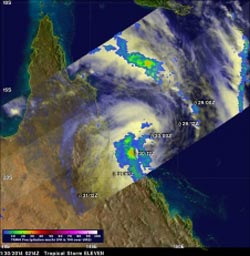
On Jan. 30 at 0214 UTC the TRMM satellite saw moderate (green) to heavy rainfall (red) falling at the rate of over 31 mm/1.2 inches per hour was preceding Dylan's movement toward the Australian coast. Image Credit: SSAI/NASA, Hal Pierce<br>
Tropical storm Dylan was heading from the Coral Sea toward Australia's Queensland coast when it was viewed by the Tropical Rainfall Measuring Mission (TRMM) satellite on January 30, 2014 at 0214 UTC/Jan. 29 at 9:14 a.m. EST.
A rainfall analysis was done at NASA's Goddard Space Flight Center in Greenbelt, Maryland using data collected by TRMM's Microwave Imager (TMI) and Precipitation Radar (PR) instruments. Rainfall rates were overlaid on an enhanced visible/infrared image from TRMM's Visible and InfraRed Scanner (VIRS) to complete the analysis. TRMM's TMI data revealed that moderate to heavy rainfall falling at the rate of over 31 mm/1.2 inches per hour was preceding Dylan's movement toward the Australian coast.
On January 31 at 0300 UTC/Jan. 30 at 10 p.m. EST, the Joint Typhoon Warning Center issued its final bulletin on Tropical Cyclone Dylan. By that time, Dylan had made landfall and was moving inland. It was centered about 178 nautical miles/204.8 miles/329.7 km southeast of Cairns, Australia near 21.3 south and 147.9 east. Dylan had maximum sustained winds near 40 knots/46 mph/74.0 kph and was quickly weakening and dissipating as it tracked over land.
At 8:02 a.m. EST on Friday, January 31, the Australian Bureau of Meteorology or ABM noted that ex-Tropical Cyclone Dylan continued moving south after crossing the coast east of Bowen early that morning. ABM warned residents from Bowen south to expect heavy rainfall from the dissipating low pressure system. ABM also noted that river rises were no longer expected from Dylan's rainfall in the Herbert, Ross, Bohle, Black and Burdekin Rivers and Bluewater Creek.
Text credit: Hal Pierce/Rob Gutro
SSAI/NASA Goddard Space Flight Center
Media Contact
All latest news from the category: Earth Sciences
Earth Sciences (also referred to as Geosciences), which deals with basic issues surrounding our planet, plays a vital role in the area of energy and raw materials supply.
Earth Sciences comprises subjects such as geology, geography, geological informatics, paleontology, mineralogy, petrography, crystallography, geophysics, geodesy, glaciology, cartography, photogrammetry, meteorology and seismology, early-warning systems, earthquake research and polar research.


Newest articles

Solving the riddle of the sphingolipids in coronary artery disease
Weill Cornell Medicine investigators have uncovered a way to unleash in blood vessels the protective effects of a type of fat-related molecule known as a sphingolipid, suggesting a promising new…
Rocks with the oldest evidence yet of Earth’s magnetic field
The 3.7 billion-year-old rocks may extend the magnetic field’s age by 200 million years. Geologists at MIT and Oxford University have uncovered ancient rocks in Greenland that bear the oldest…

Decisive breakthrough for battery production
Storing and utilising energy with innovative sulphur-based cathodes. HU research team develops foundations for sustainable battery technology Electric vehicles and portable electronic devices such as laptops and mobile phones are…

