TRMM satellite peers at rainfall in developing low near Mozambique
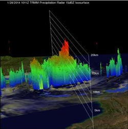
TRMM satellite flew above a tropical low (91S) in the Mozambique Channel on Jan. 28, 2014, at 1011 UTC and this 3-D view using TRMM PR data shows that some towering storms near the center of the low were reaching heights of above 16km (about 9.9 miles).<br><br>Credit: NASA/SSAI, Hal Pierce<br>
An analysis of rainfall from TRMM's Microwave Imager (TMI) and Precipitation Radar (PR) instruments are shown on the left overlaid on a visible/infrared image from TRMM's Visible and InfraRed Scanner (VIRS). TRMM PR measured rain falling at the rate of over 134.9 mm/~5.3 inches per hour in a band of powerful convective thunderstorms north of the center of circulation.
A 3-D view was created at NASA's Goddard Space Flight Center in Greenbelt, Md. using TRMM PR data. That image showed that some towering storms near the center of the low were reaching heights of above 16 km/9.9 miles. Towers this tall near the center of the tropical low are often an indication of tropical cyclone formation or intensification.
On January 29 at 1430 UTC/9:30 a.m. EST, the Joint Typhoon Warning Center dropped System 91S from formation alert status, but the low pressure area still has a medium chance for development in the next 24 hours. System 91S was located near 18.2 south and 39.1 east, about 585 nautical miles northeast of Maputo, Mozambique.
An image from India's Oceansat satellite indicated 20 to 25 knot (37.0 to 46.3 kph/23.0 to 28.7 mph winds over the eastern semi-circle of the storm. Meanwhile the NOAA-19 polar orbiting satellite data showed weak, shallow convective banding of thunderstorms wrapping into the low-level center on January 29.
System 91S is located in an environment with moderate vertical wind shear. The Joint Typhoon Warning Center noted that dynamic computer model guidance shows System 91S should weaken as it continues moving to the southwest.
Only one named tropical cyclone called Deliwe has passed through the Mozambique Channel so far this year but this analysis found that areas of the Mozambique Channel from southeastern Mozambique through western Madagascar have already had well above normal rainfall for the past 30 days.
Media Contact
More Information:
http://www.nasa.govAll latest news from the category: Earth Sciences
Earth Sciences (also referred to as Geosciences), which deals with basic issues surrounding our planet, plays a vital role in the area of energy and raw materials supply.
Earth Sciences comprises subjects such as geology, geography, geological informatics, paleontology, mineralogy, petrography, crystallography, geophysics, geodesy, glaciology, cartography, photogrammetry, meteorology and seismology, early-warning systems, earthquake research and polar research.


Newest articles

Superradiant atoms could push the boundaries of how precisely time can be measured
Superradiant atoms can help us measure time more precisely than ever. In a new study, researchers from the University of Copenhagen present a new method for measuring the time interval,…

Ion thermoelectric conversion devices for near room temperature
The electrode sheet of the thermoelectric device consists of ionic hydrogel, which is sandwiched between the electrodes to form, and the Prussian blue on the electrode undergoes a redox reaction…

Zap Energy achieves 37-million-degree temperatures in a compact device
New publication reports record electron temperatures for a small-scale, sheared-flow-stabilized Z-pinch fusion device. In the nine decades since humans first produced fusion reactions, only a few fusion technologies have demonstrated…

