TRMM Eyes Rainfall in Dissipating Former Hurricane Cristina
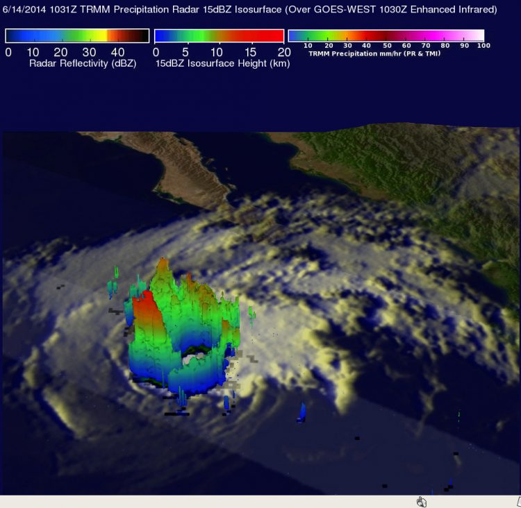
On June 14, NASA's TRMM satellite found rain falling at a rate of almost 97 mm (about 3.8 inches) per hour in the northwestern side of Cristina's eye wall where thunderstorms reached above 13.5 km (about 8.4 miles). Image Credit: SSAI/NASA, Hal Pierce
Hurricane Cristina had sustained winds of over 130 knots (almost 150 mph) on June 12, 2014 making her the second hurricane in the eastern Pacific Ocean this year to reach category four on the Saffir-Simpson hurricane wind scale.
The TRMM satellite had an excellent view of Cristina when it flew over on June 14, 2014 at 1031 UTC (6:31 a.m. EDT). At that time, Cristina had started weakening and had wind speeds estimated at less than 70 knots (about 80 mph) when TRMM flew overhead.
To form a complete picture of the storm, rainfall from TRMM's Microwave Imager (TMI) and Precipitation Radar (PR) instruments were overlaid on an enhanced infrared image of Cristina's clouds taken from NOAA's GOES-West satellite. The images were combined at NASA's Goddard Space Flight Center in Greenbelt, Maryland.
Although Cristina had started a weakening trend TRMM's Precipitation Radar instrument still found rain falling at a rate of almost 97 mm (about 3.8 inches) per hour in the northwestern side of Cristina's eye wall. At Goddard, TRMM's PR data was used to create a 3-D view of the Cristina's rainfall structure.
That 3-D image showed powerful thunderstorms in the northwestern side of the storm were reaching heights above 13.5 km (about 8.4 miles). These same TRMM data showed that Cristina's eye wall was broken on the eastern side.
The passage of Cristina over cooler ocean waters and southwesterly wind shear resulted in the once powerful hurricane dissipating to a remnant low pressure area on Sunday, June 15, 2014.
On June 17 at 09:02 a.m. EDT, the National Hurricane Center (NHC) noted that the remnant low pressure center of Cristina continued to spin in the Eastern Pacific, and the circulation center was located near 23 north latitude and 117 west longitude.
NHC forecasters noted that the circulation will continue to spin down over the next couple of days and is expected to dissipate by the night time hours on Wednesday, June 18.
Text credit: Hal Pierce
SSAI/NASA's Goddard Space Flight Center
Media Contact
More Information:
http://www.nasa.gov/content/goddard/cristina-eastern-pacific-ocean/All latest news from the category: Earth Sciences
Earth Sciences (also referred to as Geosciences), which deals with basic issues surrounding our planet, plays a vital role in the area of energy and raw materials supply.
Earth Sciences comprises subjects such as geology, geography, geological informatics, paleontology, mineralogy, petrography, crystallography, geophysics, geodesy, glaciology, cartography, photogrammetry, meteorology and seismology, early-warning systems, earthquake research and polar research.


Newest articles

High-energy-density aqueous battery based on halogen multi-electron transfer
Traditional non-aqueous lithium-ion batteries have a high energy density, but their safety is compromised due to the flammable organic electrolytes they utilize. Aqueous batteries use water as the solvent for…

First-ever combined heart pump and pig kidney transplant
…gives new hope to patient with terminal illness. Surgeons at NYU Langone Health performed the first-ever combined mechanical heart pump and gene-edited pig kidney transplant surgery in a 54-year-old woman…

Biophysics: Testing how well biomarkers work
LMU researchers have developed a method to determine how reliably target proteins can be labeled using super-resolution fluorescence microscopy. Modern microscopy techniques make it possible to examine the inner workings…

