Thunderstorms in Beatriz Show Strengthening Toward Hurricane Status
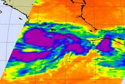
NASA's Aqua satellite passed over Tropical Storm Beatriz on June 20 at 08:11 UTC and the AIRS instrument captured this infrared image of the storm. The image showed a more rounded and organized circulation with strong convection (purple) and cloud tops as cold as -63F/-52C.<br>Credit: NASA/JPL, Ed Olsen <br>
Beatriz formed from the low pressure area System 92E that NASA and JAXA's Tropical Rainfall Measuring Mission (TRMM) was watching last week. The low pressure area was coming together on Friday, June 17 and had some isolated areas of heavy rainfall. Those areas of heavy rainfall have increased as the low organized and strengthened over the weekend. On June 19 at 11 a.m. EDT it became tropical depression two-E. Just three hours later it reached tropical storm strength and was named Beatriz.
Infrared imagery on June 19 and 20 from the Atmospheric Infrared Sounder (AIRS) instrument that flies aboard NASA's Aqua satellite showed that cloud tops are cooling, indicating growing and higher thunderstorms. Typically – the higher the thunderstorm, the stronger the storm. Those cloud top temperatures in infrared imagery reached the threshold of strongest storms/coldest cloud tops, for the AIRS data of temperatures as cold as or colder than -63 Fahrenheit (-52 Celsius).
When NASA's Aqua satellite passed over Tropical Storm Beatriz on June 19, 2011 at 1959 UTC 3:59 p.m. EDT) hours after it reached tropical storm strength, the storm appeared somewhat elongated. At that time, Beatriz had maximum sustained winds near 40 mph.
By June 20 at 08:11 UTC (4:11 a.m. EDT) the AIRS instrument on NASA's Aqua satellite showed a more rounded and organized circulation with strong convection. Meteorologists at the National Hurricane Center use this data with other satellite data in their forecasts and expect Beatriz to reach hurricane status later today.
As a result, a hurricane warning is in effect for the western Mexican coast from Zihuatanejo northwestward to La Fortuna and a watch extends from there northward to Cabo Corrientes. In addition, tropical storm warnings are in effect from Tecpan De Galeana westward to east of Zihuatanejo and from north of La Fortuna to Cabo Corrientes.
Maximum sustained winds were near 65 mph/100 kmh). It was about 125 miles (205 km) south-southwest of Lazaro Cardenas, Mexico and 210 miles (335 km) south-southeast of Beatriz is moving to the northwest near 9 mph (15 kmh) and has a minimum central pressure of 995 millibars.
Coastal communities in the warning and watch area should be prepared for tropical storm conditions today followed by hurricane conditions tonight. Rainfall is expected to be excessive between 6 and 12 inches in the states of Guerrero, Jalisco, Colima and Michoacan in southwestern Mexico with isolated amounts to 20 inches in mountainous areas. That means life-threatening flash floods and mudslides are possible. Coastal areas, however, face flooding from storm surge.
Text credit: Rob Gutro, NASA's Goddard Space Flight Center, Greenbelt, Md.
Media Contact
All latest news from the category: Earth Sciences
Earth Sciences (also referred to as Geosciences), which deals with basic issues surrounding our planet, plays a vital role in the area of energy and raw materials supply.
Earth Sciences comprises subjects such as geology, geography, geological informatics, paleontology, mineralogy, petrography, crystallography, geophysics, geodesy, glaciology, cartography, photogrammetry, meteorology and seismology, early-warning systems, earthquake research and polar research.


Newest articles

Superradiant atoms could push the boundaries of how precisely time can be measured
Superradiant atoms can help us measure time more precisely than ever. In a new study, researchers from the University of Copenhagen present a new method for measuring the time interval,…

Ion thermoelectric conversion devices for near room temperature
The electrode sheet of the thermoelectric device consists of ionic hydrogel, which is sandwiched between the electrodes to form, and the Prussian blue on the electrode undergoes a redox reaction…

Zap Energy achieves 37-million-degree temperatures in a compact device
New publication reports record electron temperatures for a small-scale, sheared-flow-stabilized Z-pinch fusion device. In the nine decades since humans first produced fusion reactions, only a few fusion technologies have demonstrated…

