Three NASA satellites dissect powerful Typhoon Neoguri
NASA's TRMM Satellite Sees Heavy Rainfall in Typhoon Neoguri On July 7 at 2:41 a.m. EDT the TRMM satellite had a near perfect view as it passed above the center of Typhoon Neoguri. Heaviest rainfall was occurring at over 106 mm (4.2) inches per hour in feeder bands southeast of Neoguri's eye. Credit: NASA/SSAI, Hal Pierce
Typhoon Neoguri formed in the western Pacific Ocean south-southeast of Guam on July 3, 2014. Since then Neoguri has become increasingly more powerful and dangerous. The word Neoguri means “raccoon” in Korean. On July 5 at 0426 UTC (12:26 a.m. EDT) NASA's CloudSat satellite passed over Typhoon Neoguri when its maximum sustained winds were near 110 knots (127 mph).
CloudSat passed over the western edge of the center of the storm revealing a portion of eye and eye wall structure. CloudSat found that a canopy or covering of high, wispy cirrus clouds covered the eye, and that there was a small area of cumulus and stratocumulus clouds near the surface.
NASA's TRMM Satellite Sees Heavy Rainfall in Typhoon Neoguri On July 7 at 2:41 a.m. EDT the TRMM satellite had a near perfect view as it passed above the center of Typhoon Neoguri. Heaviest rainfall was occurring at over 106 mm (4.2) inches per hour in feeder bands southeast of Neoguri's eye.
When CloudSat passed overhead, Typhoon Neoguri had a notably large eye with meso vorticies (small scale rotational areas usually found in an intensifying tropical cyclone as was the case with Neoguri) in the inner eye. CloudSat passed over Neoguri from northwest to southeast and cut through the center of the storm.
CloudSat found a wide area of moderate to heavy rainfall and convection (rising air that forms thunderstorms) south of the eyewall and outer bands. CloudSat also provided a side view of the extent of Neoguri's clouds, and found the cirrus canopy extends hundreds of miles/kilometers outward from the center.
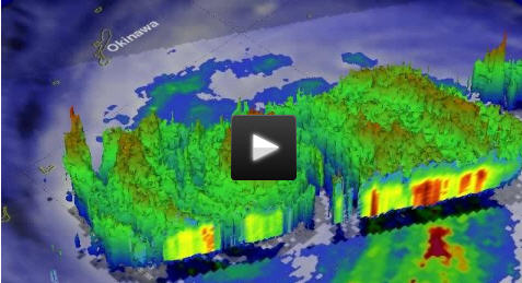
On July 7 at 0641 UTC (2:41 a.m. EDT) NASA and the Japan Aerospace Exploration Agency's Tropical Rainfall Measuring Mission or TRMM satellite had a near perfect view as it passed above the center of Typhoon Neoguri. At that time, Neoguri was classified as a category four typhoon on the Saffir-Simpson hurricane scale with sustained winds estimates at 135 knots (155 mph).
Rainfall from TRMM's Microwave Imager (TMI) and Precipitation Radar (PR) revealed that Neoguri's nearly circular eye wall contained intense thunderstorms. TRMM PR found that the heaviest precipitation was occurring at a rate of over 106 mm (about 4.2) inches per hour in feeder bands southeast of Neoguri's eye.
At NASA's Goddard Space Flight Center in Greenbelt, Maryland, TRMM's Precipitation Radar data was used to create a 3-D simulated view that showed Neoguri's circular eye wall was unbroken and contained storms that were uniformly reaching heights of 13 to 15 km (8 to 9.3 miles).
On July 8 at 0500 UTC (1 a.m. EDT), NASA's Aqua satellite passed over Typhoon Neoguri when it was in the East China Sea. The Moderate Resolution Imaging Spectroradiometer or MODIS instrument captured a visible image of the storm that shows some cirrus clouds in a mostly clear eye. Neoguri's center was due west of Kume Island. Kume Island is a populated volcanic island that is part of the Okinawa Islands and the Okinawa Prefecture, Japan.
As Aqua passed over Neoguri, another instrument aboard captured infrared data on the storm's clouds and temperatures. The Atmospheric Infrared Sounder or AIRS instrument found cold cloud tops in powerful thunderstorms around the eyewall (wall of thunderstorms around the storm's open center) were as cold as -70C to -80C (-94F to -112F) degrees. AIRS showed an eye that was about 25 nautical-miles (28.7 miles/46.3 km) wide.
On July 8 at 1500 UTC (11 a.m. EDT) Neoguri's maximum sustained winds had dropped to 105 knots. It was centered near 28.3 north latitude and 125.8 east longitude, about 379 nautical miles (436 miles/702 miles) southwest of Sasebo, Japan. The Joint Typhoon Warning Center or JTWC noted that Neoguri was moving to the north at 13 knots (14.9 mph/24.0 kph), but forecasts a change to the northeast. Neoguri is creating large and dangerous swells with wave heights to 37 feet (11.2 meters).
The JTWC predicts Typhoon Neoguri will turn to the east and make landfall in southern Kyushu slightly after 0000 UTC on July 10 (8 p.m. EDT on July 9).
Media Contact
All latest news from the category: Earth Sciences
Earth Sciences (also referred to as Geosciences), which deals with basic issues surrounding our planet, plays a vital role in the area of energy and raw materials supply.
Earth Sciences comprises subjects such as geology, geography, geological informatics, paleontology, mineralogy, petrography, crystallography, geophysics, geodesy, glaciology, cartography, photogrammetry, meteorology and seismology, early-warning systems, earthquake research and polar research.


Newest articles

Silicon Carbide Innovation Alliance to drive industrial-scale semiconductor work
Known for its ability to withstand extreme environments and high voltages, silicon carbide (SiC) is a semiconducting material made up of silicon and carbon atoms arranged into crystals that is…

New SPECT/CT technique shows impressive biomarker identification
…offers increased access for prostate cancer patients. A novel SPECT/CT acquisition method can accurately detect radiopharmaceutical biodistribution in a convenient manner for prostate cancer patients, opening the door for more…

How 3D printers can give robots a soft touch
Soft skin coverings and touch sensors have emerged as a promising feature for robots that are both safer and more intuitive for human interaction, but they are expensive and difficult…

