Tapah downgrades to a depression
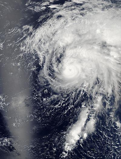
Aqua captured this image of the tropical depression Tapah on April 29, 2014, at 11:55 p.m. EDT (3:55 UTC) in the western Pacific Ocean. Credit: NASA Goddard's MODIS Rapid Response Team
Tapah rapidly dissipated due to the effected of strong vertical windshear from the west and a sharp decreased in sea surface temperature.
The storm is currently tracking northwest at 10 knots per hour and is expected to recurve to the northeast and accelerate.
Maximum wave height is currently 10 feet. The storm will be monitored for signs of regeneration.
NASA captured this image of the storm with the Moderate Resolution Imaging Spectroradiometer or MODIS instrument aboard NASA's Aqua satellite on April 29, 2014 at 11:55 p.m. EDT (3:55 UTC) in the western Pacific Ocean.
Media Contact
More Information:
http://www.nasa.govAll latest news from the category: Earth Sciences
Earth Sciences (also referred to as Geosciences), which deals with basic issues surrounding our planet, plays a vital role in the area of energy and raw materials supply.
Earth Sciences comprises subjects such as geology, geography, geological informatics, paleontology, mineralogy, petrography, crystallography, geophysics, geodesy, glaciology, cartography, photogrammetry, meteorology and seismology, early-warning systems, earthquake research and polar research.


Newest articles

Machine learning algorithm reveals long-theorized glass phase in crystal
Scientists have found evidence of an elusive, glassy phase of matter that emerges when a crystal’s perfect internal pattern is disrupted. X-ray technology and machine learning converge to shed light…

Mapping plant functional diversity from space
HKU ecologists revolutionize ecosystem monitoring with novel field-satellite integration. An international team of researchers, led by Professor Jin WU from the School of Biological Sciences at The University of Hong…

Inverters with constant full load capability
…enable an increase in the performance of electric drives. Overheating components significantly limit the performance of drivetrains in electric vehicles. Inverters in particular are subject to a high thermal load,…

