Satellites See Ups and Downs of Two Tropical Eastern Pacific Systems
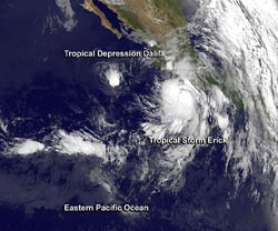
NOAA’s GOES-15 satellite captured both Tropical Depression Dalila and Tropical Storm Erick in one view on July 5 at 1200 UTC (8 a.m. EDT) as they were moving through the Eastern Pacific Ocean.<br>Image Credit: NASA GOES Project <br>
Tropical Depression Dalila has weakened from a Category 1 hurricane status and is expected to dissipate in the next day or two. Meanwhile, Tropical Storm Erick grew from a low pressure area called System 97E into the fifth tropical depression on July 4 and then into a tropical storm later in the day.
NOAA’s GOES-15 satellite captured an image of the two tropical cyclones just before daylight reached the Pacific coast on July 5 at 1200 UTC (8 a.m. EDT/5 a.m. PDT). In the GOES-15 infrared image, Tropical Storm Erick is 550 nautical miles east of the much smaller Tropical Depression Dalila. Because of the close proximity of the storms, the National Hurricane Center bulletin of July 5 at 11 a.m. EDT noted Tropical Depression Dalila does not have much of a future as a tropical cyclone due to moderate southeasterly vertical wind shear being created by the outflow from Tropical Storm Erick.
NOAA manages the GOES-15 satellite, and the NASA GOES Project at NASA’s Goddard Space Flight Center in Greenbelt, Md. created the image.
Tropical Depression Dalila
At 11 a.m. EDT on July 4, Dalila was a tropical storm with maximum sustained winds near 40 mph (65 kph). It was centered near 17.4 north and 109.8 west, about 380 miles (610 km) south of the southern tip of Baja California.
Twenty-four hours later at 11 a.m. EDT on July 5, Dalila had weakened further and was a tropical depression. At that time, Dalila’s maximum sustained winds were near 35 mph (55 kph). It had moved to 17.1 north and 111.7 west, about 415 miles (670 km) south-southwest of the southern tip of Baja California. Dalila was still moving to the west, but had slowed to 3 mph (6 kph) and had a minimum central pressure of 1006 millibars.
There are two things that are forcing Dalila's demise: dry air and wind shear. Wind shear from the east has been battering Dalila and dry air has moved into the storm suppressing formation of thunderstorms. Dalila is expected to become a remnant low in the next day or two.
Tropical Storm Erick
Tropical storm warnings are now in effect for the coast of southwestern Mexico eastward to Zihautanejo and westward to La Fortuna, Mexico. There is also a tropical storm watch now in effect for the coast of southwestern Mexico from west of La Fortuna to Cabo Corrientes.
Those warnings and watches are in effect as of July 5 because Tropical Storm Erick is near the coast and strengthening. The National Hurricane Center expects Erick may strengthen to hurricane force by Saturday, July 6. That would make Erick the fourth hurricane of the Eastern Pacific Hurricane Season out of five storms to form.
At 11 a.m. EDT on July 5, the National Hurricane Center (NHC) noted the Erick was located about 150 miles (245 km) south of Lazaro Cardenas, Mexico, near latitude 15.8 north and longitude 102.1 west. Erick’s maximum sustained winds had grown to 60 mph (95 kph) and strengthening is expected. Erick is moving to the west-northwest near 10 mph (17 kph) and is expected to continue moving in that direction over the next several days.
Tropical-storm-force winds extend outward up to 90 miles (150 km) from the center and the GOES-15 imagery shows that Erick’s cloud cover has a larger extent.
Residents in the warning area can expect 3 to 5 inches over southwestern Oaxaca, southern Guerrero, southern Michoaca, Colima, and southern Jalisco, Mexico. The NHC noted that isolated totals could reach up to 8 inches in those areas. Tropical-storm-force winds are expected in the warning area today, July 5 and on July 6. Coastal areas can also expect rough surf as Erick moves up the coast.
Text credit: Rob Gutro, NASA's Goddard Space Flight Center, Greenbelt, Md.
Media Contact
All latest news from the category: Earth Sciences
Earth Sciences (also referred to as Geosciences), which deals with basic issues surrounding our planet, plays a vital role in the area of energy and raw materials supply.
Earth Sciences comprises subjects such as geology, geography, geological informatics, paleontology, mineralogy, petrography, crystallography, geophysics, geodesy, glaciology, cartography, photogrammetry, meteorology and seismology, early-warning systems, earthquake research and polar research.


Newest articles

Eruption of mega-magnetic star lights up nearby galaxy
Thanks to ESA satellites, an international team including UNIGE researchers has detected a giant eruption coming from a magnetar, an extremely magnetic neutron star. While ESA’s satellite INTEGRAL was observing…

Solving the riddle of the sphingolipids in coronary artery disease
Weill Cornell Medicine investigators have uncovered a way to unleash in blood vessels the protective effects of a type of fat-related molecule known as a sphingolipid, suggesting a promising new…
Rocks with the oldest evidence yet of Earth’s magnetic field
The 3.7 billion-year-old rocks may extend the magnetic field’s age by 200 million years. Geologists at MIT and Oxford University have uncovered ancient rocks in Greenland that bear the oldest…

