Satellites Tracking Central Pacific's Tropical Storm Ana
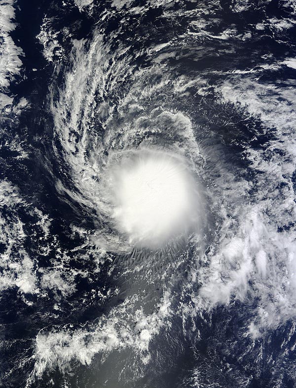
On Oct. 15 at 20:30 UTC (4:30 p.m. EDT) NASA's Terra satellite captured this image of Tropical Storm Ana in the Central Pacific Ocean. Image Credit: NASA Goddard MODIS Rapid Response Team
NOAA's Central Pacific Hurricane Center (CPHC) has issued a Tropical Storm Watch for Hawaii County, Hawaii. A tropical storm watch means that tropical storm conditions are possible within the watch area, in this case within 36 to 48 hours. Life-threatening surf and riptide conditions will start to affect the Hawaiian Islands from Thursday onwards. Heavy rainfall will reach the Big Island on Friday, causing life-threatening flash floods and mud slides.
Interests elsewhere in the main Hawaiian Islands, and in the Papahanaumokuakea marine national monument area from Necker to French Frigate Shoals, should monitor the progress of Ana. Watches May be required for additional areas in the main Hawaiian Islands later today.
CPHC noted that tropical storm conditions are possible on the Big Island of Hawaii starting late Friday, Oct.17. In addition, large swells produced by Ana are possible over the eastern end of the main Hawaiian island chain starting late tonight and Friday morning. These large swells will continue to spread up the island chain through the weekend.
Surf produced by these swells could potentially be damaging along exposed shorelines beginning late Friday and Saturday, and persisting through the weekend in some areas. Heavy rainfall associated with Ana may reach the Big Island of Hawaii Friday afternoon. These rains could cause life-threatening flash floods and mud slides.
At the NASA/NOAA GOES Project office at NASA's Goddard Space Flight Center in Greenbelt, Maryland, infrared and visible image of Tropical Storm Ana were compiled from Oct. 13 through Oct. 16 and made into a movie that showed the intensification and movement of Ana. NOAA manages the GOES-West satellite.
NASA's Terra satellite passed over Tropical Storm Ana on Oct. 15 at 20:30 UTC (4:30 p.m. EDT) and the Moderate Resolution Imaging Spectroradiometer captured a visible image of the storm that showed extent of the rounded clouds. The storm appeared so rounded that it looked like a white sun.
At 500 a.m. HST (9 a.m. EDT/1500 UTC) on Oct. 16, Ana's maximum sustained winds were near 60 mph (95 kph) and gradual strengthening is expected and Ana is expected to become a hurricane on Friday, Oct. 17.
The center of Tropical Storm Ana was located near latitude 14.1 north, longitude 150.3 west. That's about 500 miles (805 km) east-southeast of Hilo, Hawaii. Ana is moving toward the west near 10 mph (17 kph) and is expected to turn to the northwest on Oct. 17. The estimated minimum central pressure is 1000 millibars.
Ana is forecast to move to the west-northwest and strengthen into a hurricane, approaching the big island of Hawaii by Saturday, Oct. 18 and then tracking parallel to the islands over the two days following. For updated forecasts, visit: http://www.prh.noaa.gov.
Rob Gutro
NASA's Goddard Space Flight Center
Media Contact
More Information:
http://www.nasa.gov/content/goddard/ana-central-pacific/All latest news from the category: Earth Sciences
Earth Sciences (also referred to as Geosciences), which deals with basic issues surrounding our planet, plays a vital role in the area of energy and raw materials supply.
Earth Sciences comprises subjects such as geology, geography, geological informatics, paleontology, mineralogy, petrography, crystallography, geophysics, geodesy, glaciology, cartography, photogrammetry, meteorology and seismology, early-warning systems, earthquake research and polar research.


Newest articles

Superradiant atoms could push the boundaries of how precisely time can be measured
Superradiant atoms can help us measure time more precisely than ever. In a new study, researchers from the University of Copenhagen present a new method for measuring the time interval,…

Ion thermoelectric conversion devices for near room temperature
The electrode sheet of the thermoelectric device consists of ionic hydrogel, which is sandwiched between the electrodes to form, and the Prussian blue on the electrode undergoes a redox reaction…

Zap Energy achieves 37-million-degree temperatures in a compact device
New publication reports record electron temperatures for a small-scale, sheared-flow-stabilized Z-pinch fusion device. In the nine decades since humans first produced fusion reactions, only a few fusion technologies have demonstrated…

