Satellite sees post-Tropical Cyclone Lane fizzle in a blanket of low clouds
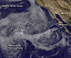
On Sept. 19 at 11:45 a.m. EDT, GOES-15 captured an image of post-tropical Lane's remnants over 1,000 miles from Baja California, in an extensive field of stratocumulus clouds.<br><br>Credit: NASA/NOAA GOES Project<br>
NOAA's GOES-15 satellite sits in a fixed orbit over the western U.S. and captures continuous visible and infrared imagery of the western U.S. and the Eastern Pacific Ocean. On Sept. 19 at 11:45 a.m. EDT, GOES-15 captured a visible image of post-tropical Lane's remnants that appear as a small circulation center.
The center was located over 1,000 miles from Baja California in an extensive field of stratocumulus clouds. Stratocumulus clouds are usually found below 8,000 feet (2,400 meters), and are shallow clouds that do not grow vertically because of stable, drier air above. The image was created by NASA's GOES Project, located at NASA's Goddard Space Flight Center in Greenbelt, Md.
At 1500 UTC (11 a.m. EDT) on Wed. Sept. 19, 2012 post-tropical cyclone Lane had maximum sustained winds were near 35 mph (55 kph) and winds were weakening as a result of the low pressure area being over waters too cool to maintain it. Sea surface temperatures in the region where Lane's remnants were located are colder than 22 degrees Celsius (71.6 Fahrenheit). In order to maintain a tropical cyclone, sea surface temperatures of 26.6 Celsius (80 Fahrenheit) are needed.
Lane was centered about 1,380 miles west of Cabo San Lucas, Mexico, near 20.9 North latitude and 131.3 West longitude. The low was moving to the west near 5 knots, and the National Hurricane Center expects Lane's remnants to continue moving west.
Lane was a post-tropical remnant low pressure area on Sept. 19 and is expected to continue steadily weakening and should dissipate into a trough (elongated area) of low pressure on Thursday, Sept. 21.
Media Contact
More Information:
http://www.nasa.govAll latest news from the category: Earth Sciences
Earth Sciences (also referred to as Geosciences), which deals with basic issues surrounding our planet, plays a vital role in the area of energy and raw materials supply.
Earth Sciences comprises subjects such as geology, geography, geological informatics, paleontology, mineralogy, petrography, crystallography, geophysics, geodesy, glaciology, cartography, photogrammetry, meteorology and seismology, early-warning systems, earthquake research and polar research.


Newest articles

Properties of new materials for microchips
… can now be measured well. Reseachers of Delft University of Technology demonstrated measuring performance properties of ultrathin silicon membranes. Making ever smaller and more powerful chips requires new ultrathin…

Floating solar’s potential
… to support sustainable development by addressing climate, water, and energy goals holistically. A new study published this week in Nature Energy raises the potential for floating solar photovoltaics (FPV)…

Skyrmions move at record speeds
… a step towards the computing of the future. An international research team led by scientists from the CNRS1 has discovered that the magnetic nanobubbles2 known as skyrmions can be…

