Satellite sees newborn Tropical Storm Fausto being 'chased'
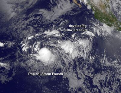
GOES-West captured this image on July 8 at 10 a.m. EDT. Tropical Storm Fausto as a rounded area of clouds, compared to the amorphous developing low pressure area behind it. Credit: NASA/NOAA GOES Project
NOAA's Geostationary Operational Environmental Satellite GOES-West captured a combination visible and infrared image of the Eastern Pacific on July 8 at 1500 UTC (10 a.m. EDT). In the image, Tropical Storm Fausto appeared as a rounded area of clouds, compared to the amorphous developing low pressure area behind it.
At 6:30 p.m. EDT on July 7, Tropical Depression Six-E formed in the Eastern Pacific about 1,145 miles (1,840 km) southwest of the southern tip of Baja California, Mexico. The depression strengthened into Tropical Storm Fausto by 11:00 p.m. EDT.
On July 8 at 11 a.m. EDT (1500 UTC), Tropical Storm Fausto had maximum sustained winds near 45 mph (75 kph) and is expected to strengthen slightly. Fausto was centered near latitude 9.7 north and longitude 123.2 west, about 1,265 miles (2,040 km) southwest of the southern tip of Baja California. Fausto is moving toward the west near 14 mph (22 kph) and the National Hurricane Center (NHC) expects a westward to West-northwestward motion at a slightly faster forward speed over the next 48 hours. The estimated minimum central pressure is 1005 millibars.
NHC forecaster Pasch noted in the 11 a.m. EDT discussion, “the center is not easy to locate, even on first-light visible images, but microwave imagery suggest that it is near the northern edge of the main area of deep convection (rising air that forms thunderstorms that make up the tropical cyclone).”
NHC expects Fausto to peak on July 9 before weakening again.
To the west of Fausto is another developing area of low pressure. Shower activity associated with a broad trough of low pressure, several hundred miles southwest of Manzanillo, Mexico. That low pressure area has become less organized over the past day. The NHC noted that development, if any should be slow to occur during the next two day as it moves west-northwestward at 10 to 15 mph. After 48 hours, upper level winds are expected to become less conducive for development.
Media Contact
More Information:
http://www.nasa.govAll latest news from the category: Earth Sciences
Earth Sciences (also referred to as Geosciences), which deals with basic issues surrounding our planet, plays a vital role in the area of energy and raw materials supply.
Earth Sciences comprises subjects such as geology, geography, geological informatics, paleontology, mineralogy, petrography, crystallography, geophysics, geodesy, glaciology, cartography, photogrammetry, meteorology and seismology, early-warning systems, earthquake research and polar research.


Newest articles

Silicon Carbide Innovation Alliance to drive industrial-scale semiconductor work
Known for its ability to withstand extreme environments and high voltages, silicon carbide (SiC) is a semiconducting material made up of silicon and carbon atoms arranged into crystals that is…

New SPECT/CT technique shows impressive biomarker identification
…offers increased access for prostate cancer patients. A novel SPECT/CT acquisition method can accurately detect radiopharmaceutical biodistribution in a convenient manner for prostate cancer patients, opening the door for more…

How 3D printers can give robots a soft touch
Soft skin coverings and touch sensors have emerged as a promising feature for robots that are both safer and more intuitive for human interaction, but they are expensive and difficult…

