Satellite sees 2 tropical cyclones chase Tropical Storm Daniel
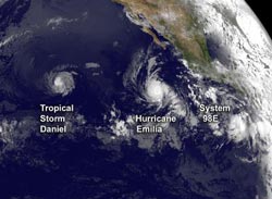
NOAA's GOES-15 satellite captured the three tropical cyclones spinning in the eastern Pacific Ocean today, July 10, 2012, at 1200 UTC (8 a.m. EDT). Tropical Storm Daniel is farthest west, followed by major hurricane Emilia, and developing low pressure System 98E. Credit: NASA/NOAA GOES Project<br>
In an image captured by NOAA's GOES-15 satellite, all three tropical cyclones were seen spinning in the eastern Pacific Ocean on July 10, 2012 at 1200 UTC (8 a.m. EDT). Daniel has weakened from a hurricane to a tropical storm and appears smaller than Hurricane Emilia.
Daniel is about 180 miles in diameter, while Emilia is over 250 miles in diameter. System 98E, the low pressure system east of Emilia, is dwarfed by the large hurricane. NOAA manages the GOES-15 satellite, and NASA's GOES Project at the NASA Goddard Space Flight Center in Greenbelt, Md. uses the data to create images and animations of weather around the U.S.
Tropical Storm Daniel's winds were now down to 65 mph (100 kmh). At 8 a.m. PDT/11 a.m. EDT, the center of Tropical Storm Daniel was located near latitude 15.3 north…longitude 135.1 west. That's about 1,350 miles (2, 175 km) east of Hilo, Hawaii. It is moving west near 16 mph (26 kmh) and is expected to keep moving in that direction over the next couple of days. Daniel is expected to weaken to tropical depression status by July 11.
On July 10 at 5 a.m. EDT, Emilia's maximum sustained winds were near 140 mph (220 kmh). By 11 a.m. EDT, Emilia's maximum sustained winds dropped to 130 mph (215 kmh) and was still holding onto Category 4 hurricane status. Emilia was located about 685 miles (1100 km) south-southwest of the southern tip of Baja California. Emilia is moving at 10 mph (17 kmh) to the west-northwest.
System 98E is slowly coming together, and has a 40 percent chance of becoming a tropical depression in the next day or two.
Media Contact
More Information:
http://www.nasa.govAll latest news from the category: Earth Sciences
Earth Sciences (also referred to as Geosciences), which deals with basic issues surrounding our planet, plays a vital role in the area of energy and raw materials supply.
Earth Sciences comprises subjects such as geology, geography, geological informatics, paleontology, mineralogy, petrography, crystallography, geophysics, geodesy, glaciology, cartography, photogrammetry, meteorology and seismology, early-warning systems, earthquake research and polar research.


Newest articles

Superradiant atoms could push the boundaries of how precisely time can be measured
Superradiant atoms can help us measure time more precisely than ever. In a new study, researchers from the University of Copenhagen present a new method for measuring the time interval,…

Ion thermoelectric conversion devices for near room temperature
The electrode sheet of the thermoelectric device consists of ionic hydrogel, which is sandwiched between the electrodes to form, and the Prussian blue on the electrode undergoes a redox reaction…

Zap Energy achieves 37-million-degree temperatures in a compact device
New publication reports record electron temperatures for a small-scale, sheared-flow-stabilized Z-pinch fusion device. In the nine decades since humans first produced fusion reactions, only a few fusion technologies have demonstrated…

