Satellite Panorama of Fizzling Juliette and Two Lows in Eastern Pacific
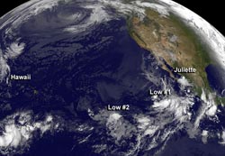
On Aug. 30, NOAA's GOES-West satellite captured the fizzling post-tropical cyclone Juliette near the Mexican coast, and two other low pressure areas that are struggling to develop. <br><br>Image Credit: NASA GOES Project<br>
NOAA's GOES-West satellite sits in a fixed orbit that covers the western U.S. and the Pacific Ocean, providing imagery on a continual basis. NASA's GOES Project at the NASA Goddard Space Flight Center in Greenbelt, Md. created a panoramic image of the Pacific that showed the weakening post-tropical cyclone Juliette and two low pressure areas on Aug. 30 at 1200 UTC/8 a.m. EDT.
The National Hurricane Center issued their final warning on post-tropical cyclone Juliette on Aug. 30 at 0300 UTC/Aug. 29 at 11 p.m. EDT. At that time, Juliette was located near 26.7 north and 114.8 west, about 80 miles south-southeast of Punta Eugenia, Mexico. Juliette was moving to the northwest at 12 knots. Its maximum sustained winds were down to 25 knots. Although Juliette no longer qualifies as a tropical cyclone, its remnants will be producing showers over Baja California today.
One of the two developing low pressure areas in the Eastern Pacific sits about 525 miles southwest of the southern tip of Baja California. The low is disorganized by has some showers associated with it. It is moving north at 10 to 15 mph toward cooler waters, which is expected to inhibit any development. The low has just a 20 percent chance of becoming a tropical depression today and over the next five days, according to the National Hurricane Center.
The second low pressure area isn't faring any better in the development category. This low is located 1,000 miles away from the first area. It is centered about 1,550 miles west-southwest of the southern tip of Baja California and is moving northeastward. This low has a 10 percent chance of development into a tropical depression in the next two days.
Text credit: Rob Gutro
NASA's Goddard Space Flight Center
Media Contact
All latest news from the category: Earth Sciences
Earth Sciences (also referred to as Geosciences), which deals with basic issues surrounding our planet, plays a vital role in the area of energy and raw materials supply.
Earth Sciences comprises subjects such as geology, geography, geological informatics, paleontology, mineralogy, petrography, crystallography, geophysics, geodesy, glaciology, cartography, photogrammetry, meteorology and seismology, early-warning systems, earthquake research and polar research.


Newest articles

Superradiant atoms could push the boundaries of how precisely time can be measured
Superradiant atoms can help us measure time more precisely than ever. In a new study, researchers from the University of Copenhagen present a new method for measuring the time interval,…

Ion thermoelectric conversion devices for near room temperature
The electrode sheet of the thermoelectric device consists of ionic hydrogel, which is sandwiched between the electrodes to form, and the Prussian blue on the electrode undergoes a redox reaction…

Zap Energy achieves 37-million-degree temperatures in a compact device
New publication reports record electron temperatures for a small-scale, sheared-flow-stabilized Z-pinch fusion device. In the nine decades since humans first produced fusion reactions, only a few fusion technologies have demonstrated…

