New satellite maps of Haiti coming in
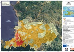
Damage around Port-au-Prince, Haiti<br>Damage evaluation map based on satellite data over the Port-au-Prince area of Haiti, following a 7.0 magnitude earthquake and several aftershocks that hit the Caribbean nation on 12 January. Map based on data from CNES\'s SPOT-5, JAXA\'s ALOS and the U.S.-based GeoEye-1 satellites; processed by SERTIT. Credits: CNES, JAXA, GeoEye, SERTIT<br>
Following the 7.0-magnitude earthquake that hit Haiti on 12 January, international agencies requested satellite data of the area from the International Charter on 'Space and Major Disasters'.
The Charter, an international initiative aimed at providing satellite data free of charge to those affected by disasters anywhere in the world, immediately began re-tasking their satellites to get the data urgently needed.
Data are being collected by various satellites including Japan’s ALOS, CNES’s Spot-5, the U.S.’s WorldView and QuickBird, Canada’s RADARSAT-2, China’s HJ-1-A/B and ESA’s ERS-2 and Envisat.
These data are being processed into maps that show the degree of destruction. As soon as new data arrives, updated maps will be produced and made available to the international community. The updates may be accessed by clicking on the links on the right.
Other satellite missions that are complementing those from the Charter include Germany’s TerraSAR-X, Italy’s COSMO-SkyMed, South Korea’s KOMPSAT-2 and the U.S.-based GeoEye-1.
Together with ESA, the Charter currently has 10 members: the French space agency (CNES), the Canadian Space Agency (CSA), the Indian Space Research Organisation (ISRO), the US National Oceanic and Atmospheric Administration (NOAA), the Argentine Space Agency (CONAE), the Japan Aerospace Exploration Agency (JAXA), the British National Space Centre/Disaster Monitoring Constellation (BNSC/DMC), the U.S. Geological Survey (USGS) and the China National Space Administration (CNSA).
Media Contact
All latest news from the category: Earth Sciences
Earth Sciences (also referred to as Geosciences), which deals with basic issues surrounding our planet, plays a vital role in the area of energy and raw materials supply.
Earth Sciences comprises subjects such as geology, geography, geological informatics, paleontology, mineralogy, petrography, crystallography, geophysics, geodesy, glaciology, cartography, photogrammetry, meteorology and seismology, early-warning systems, earthquake research and polar research.


Newest articles

Properties of new materials for microchips
… can now be measured well. Reseachers of Delft University of Technology demonstrated measuring performance properties of ultrathin silicon membranes. Making ever smaller and more powerful chips requires new ultrathin…

Floating solar’s potential
… to support sustainable development by addressing climate, water, and energy goals holistically. A new study published this week in Nature Energy raises the potential for floating solar photovoltaics (FPV)…

Skyrmions move at record speeds
… a step towards the computing of the future. An international research team led by scientists from the CNRS1 has discovered that the magnetic nanobubbles2 known as skyrmions can be…

