Satellite images display extreme Mississippi River flooding from space
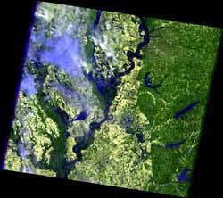
This is a Landsat 5 image of the Mississippi River in the Memphis, Tenn., area on May 10, 2011. Credit: USGS/NASA<br>
The flood crest of 47.87 feet on May 10, is the second highest rise in recent history; the highest being 48.7 feet in 1937. Five counties surrounding Memphis have been declared disaster areas, and the costs of the flooding are expected to approach $1 billion. The Mississippi River crest continues to move south and is expected to occur in the Greenville, Miss. Area around May 16 to finally crest in New Orleans around May 23.
When natural hazards like flooding occur, USGS provides the most recent Landsat data to local emergency managers.
“Landsat imagery is crucial in helping to monitor the flood rate and effects of the flooding in the region, and to aid in the decision making process regarding flood control. Decisions such as closing portions of the Mississippi River to shipping and opening flood gates outside of low-lying New Orleans in preparation to the flood wave as it makes its way slowly down the river to the Gulf of Mexico,” said Mark Anderson, Acting Director of the USGS Earth Resources Observation and Science Center.
James Irons, Landsat Data Continuity Mission (LDCM) Project Scientist at NASA Goddard Space Flight Center in Greenbelt, Md. said, “NASA Goddard has managed the development of all the successfully launched Landsat satellites and is currently developing the next Landsat satellite system, the Landsat Data Continuity Mission, in partnership with USGS.” The launch of LDCM is scheduled for December, 2012.
Remotely sensed data are not the only science endeavors occurring due to floods. The USGS collects river data through its network of about 7,700 stream gauges around the Nation. You can receive instant, customized updates about water conditions, including flooding, by subscribing to USGS WaterAlert (› http://water.usgs.gov/wateralert).
General flood information is available at USGS Science Features () and USGS Flood Information (› http://water.usgs.gov/osw/floods/).
The scenes captured by Landsat 5 show the Mississippi River in the Memphis, Tenn. area, and along the state borders of Tennessee, Kentucky, Missouri, and Arkansas. The January images show the river before it began to flood. In the May images, the dark blue tones are water, the light green is cleared fields, and the light tones are clouds.
For more NASA imagery on the current Mississippi flooding, visit:
http://earthobservatory.nasa.gov/NaturalHazards/event.php?id=49528
Media Contact
More Information:
http://www.nasa.govAll latest news from the category: Earth Sciences
Earth Sciences (also referred to as Geosciences), which deals with basic issues surrounding our planet, plays a vital role in the area of energy and raw materials supply.
Earth Sciences comprises subjects such as geology, geography, geological informatics, paleontology, mineralogy, petrography, crystallography, geophysics, geodesy, glaciology, cartography, photogrammetry, meteorology and seismology, early-warning systems, earthquake research and polar research.


Newest articles

Superradiant atoms could push the boundaries of how precisely time can be measured
Superradiant atoms can help us measure time more precisely than ever. In a new study, researchers from the University of Copenhagen present a new method for measuring the time interval,…

Ion thermoelectric conversion devices for near room temperature
The electrode sheet of the thermoelectric device consists of ionic hydrogel, which is sandwiched between the electrodes to form, and the Prussian blue on the electrode undergoes a redox reaction…

Zap Energy achieves 37-million-degree temperatures in a compact device
New publication reports record electron temperatures for a small-scale, sheared-flow-stabilized Z-pinch fusion device. In the nine decades since humans first produced fusion reactions, only a few fusion technologies have demonstrated…

