NASA Satellite Positioning Software May Aid in Tsunami Warnings
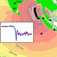
Using just 15 minutes of GPS data of ground movement at multiple ground monitoring stations, scientists were able to determine the Sumatra earthquake's true size and tsunami generation potential. Image credit: University of Nevada, Reno
A team led by Dr. Geoffrey Blewitt of the Nevada Bureau of Mines and Geology and Seismological Laboratory, University of Nevada, Reno, demonstrated that a large quake's true size can be determined within 15 minutes using GPS data. This is much faster than is possible with current methods.
“Tsunami warning is a race against time,” said co-author Dr. Seth Stein, Department of Geological Sciences, Northwestern University, Evanston, Ill. “Tsunamis travel at jet speed, so warning centers must accurately decide, within minutes, whether to issue alerts. This has to be done fast enough for the warning to be distributed to authorities in impacted areas so they can implement response plans. Together with seismometer and ocean buoy data, GPS adds another tool that can improve future tsunami danger assessments.”
“We'll always need seismology as the first level of alert for large earthquakes, and we'll need ocean buoys to actually sense the tsunami waves,” added Blewitt. “The advantage of including GPS in warning systems is that it quickly tells how much the ocean floor moved, and that information can directly set tsunami models into motion.”
The new method, called GPS displacement, works by measuring the time radio signals from GPS satellites arrive at ground stations located within a few thousand kilometers of a quake. From these data, scientists can calculate how far the stations moved because of the quake. They can then derive an earthquake model and the quake's true size, called its 'moment magnitude.' This magnitude is directly related to a quake's potential for generating tsunamis.
As illustrated by the magnitude 9.2-9.3 Sumatra quake of December 2004, current scientific methods have difficulty quickly determining moment magnitude for very large quakes. That quake was first estimated at 8.0 using seismological techniques designed for rapid analysis. Because these techniques derive estimates from the first seismic waves they record, they tend to underestimate quakes larger than about 8.5. That is the approximate size needed to generate major ocean-wide tsunamis. The initial estimate was the primary reason warning centers in the Pacific significantly underestimated the earthquake's tsunami potential.
The potential of GPS to contribute to tsunami warning became apparent after the Sumatra earthquake. GPS measurements showed that quake moved the ground permanently more than 1 centimeter (0.4 inches) as far away as India, about 2,000 kilometers (1,200 miles) away from the epicenter. “With signals like that, an earthquake this huge can't hide,” said Blewitt. “We hypothesized that if GPS data could be analyzed rapidly and accurately, they would quickly indicate the earthquake's true size and tsunami potential.”
To test the feasibility of their approach, the scientists used NASA's satellite positioning data processing software to analyze data from 38 GPS stations located at varying distances from the Sumatra quake's epicenter. The software pinpoints a station's precise location to within 7 millimeters (0.3 inches). Only data that were available within 15 minutes of the earthquake were used. Results indicated most of the permanent ground displacements occurred within a few minutes of the arrival of the first seismic waves. Their analysis inferred an earthquake model and a moment magnitude of 9.0, very near the earthquake's final calculated size.
“Modeling earthquakes with GPS requires a robust, real-time ability to predict where GPS satellites are in space with exacting precision, which our software does,” said Dr. Frank Webb, a JPL geologist. “This technique improves rapid estimates of the true size of great earthquakes and advances real-time tsunami modeling capabilities.”
Results of the study are published in Geophysical Research Letters.
Other media contacts include Jill Boudreaux, University of Nevada, Reno, 775-784-4611; Megan Fellman, Northwestern University, 847-491-3115; and Harvey Leifert, American Geophysical Union, Washington, 202-777-7507.
JPL is managed for NASA by the California Institute of Technology.
Media Contact
More Information:
http://www.unr.eduAll latest news from the category: Earth Sciences
Earth Sciences (also referred to as Geosciences), which deals with basic issues surrounding our planet, plays a vital role in the area of energy and raw materials supply.
Earth Sciences comprises subjects such as geology, geography, geological informatics, paleontology, mineralogy, petrography, crystallography, geophysics, geodesy, glaciology, cartography, photogrammetry, meteorology and seismology, early-warning systems, earthquake research and polar research.


Newest articles

Silicon Carbide Innovation Alliance to drive industrial-scale semiconductor work
Known for its ability to withstand extreme environments and high voltages, silicon carbide (SiC) is a semiconducting material made up of silicon and carbon atoms arranged into crystals that is…

New SPECT/CT technique shows impressive biomarker identification
…offers increased access for prostate cancer patients. A novel SPECT/CT acquisition method can accurately detect radiopharmaceutical biodistribution in a convenient manner for prostate cancer patients, opening the door for more…

How 3D printers can give robots a soft touch
Soft skin coverings and touch sensors have emerged as a promising feature for robots that are both safer and more intuitive for human interaction, but they are expensive and difficult…

