ERS-2 helps detect massive rivers under Antarctica
British scientists have discovered rivers the size of the Thames in London flowing hundreds of miles under the Antarctica ice shelf by examining small changes in elevation, observed by ESA’s ERS-2 satellite, in the surface of the oldest, thickest ice in the region, according to an article published in Nature this week.
The finding, which came as a great surprise to the scientists, challenges the widely held assumption that subglacial lakes evolved in isolated conditions for several millions of years and raises the possibility that large floods of water from deep within the ice’s interior may have generated huge floods that reached the ocean in the past and may do so again.
Prof. Duncan Wingham, of the University College London, who led the team said: “Previously, it was thought that water moves underneath the ice by very slow seepage. But this new data shows that, every so often, the lakes beneath the ice pop off like champagne corks, releasing floods that travel very long distances.”
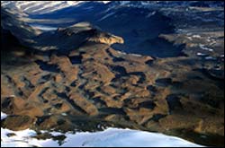
The team found anomalies in the ice-sheet surface elevation using ultra-precise measurements from ERS-2’s radar altimetry and radar interferometry. Close inspection of one anomaly revealed an abrupt fall in ice-surface elevation with a corresponding abrupt rise some 290 kilometres away. The scientists state the only possible explanation for these changes is that a large flow of water was transferred beneath the ice from one subglacial lake into several others.
Radar altimeters – originally designed to measure the sea surface height by sending 1800 separate radar pulses down to Earth per second then recording how long their echoes take to bounce back – have been highly successful in measuring large-scale ice surface changes over time. Radar interferometry, known as InSAR, is used to precisely measure the spatial pattern of the changes. Together, they form a powerful ’instrument’ to investigate the physical causes of changes in the ice surface.
According to Prof. Wingham, Director of the Centre for Polar Observation and Modelling (CPOM), both sensors were essential for the study. “With radar altimetry we can tell how much the lake levels fell and rose, and that it occurred between late 1996 and early 1998, but we cannot determine the area, which is vital for investigating the physics of the flood because we need to know the volume of water involved.
“Hence we turned to ERS-2 InSAR interferometry, which has excellent spatial resolution. With it, we were able to image the area of at least part of one lake, which was enough to give us an idea of the volume, and with this we could get at the rate of the flow.”
Subglacial lakes in Antarctica were first identified in the 1960s. Since then over 150 have been discovered but it is thought thousands may exist, as much of the bed of Antarctica remains unexamined. The team focused its study on the Dome Concordia region in East Antarctica, where more than 40 lakes are known to be.
Several groups, under the umbrella of the Scientific Committee on Antarctic Research (SCAR), are currently investigating the prospect of drilling down to subglacial Antarctic lakes where ancient life is thought to exist. However, in light of this discovery, these plans may need to be reviewed.
“A major concern has been that by drilling down to the lakes new microbes would be introduced. Our data shows that any contamination will not be limited to one lake, but will over time extend down the length of the network of rivers. We had thought of these lakes as isolated biological laboratories. Now we are going to have to think again,” Prof. Wingham said.
Media Contact
More Information:
http://www.esa.int/esaEO/SEMA94OFGLE_planet_0.htmlAll latest news from the category: Earth Sciences
Earth Sciences (also referred to as Geosciences), which deals with basic issues surrounding our planet, plays a vital role in the area of energy and raw materials supply.
Earth Sciences comprises subjects such as geology, geography, geological informatics, paleontology, mineralogy, petrography, crystallography, geophysics, geodesy, glaciology, cartography, photogrammetry, meteorology and seismology, early-warning systems, earthquake research and polar research.


Newest articles

Superradiant atoms could push the boundaries of how precisely time can be measured
Superradiant atoms can help us measure time more precisely than ever. In a new study, researchers from the University of Copenhagen present a new method for measuring the time interval,…

Ion thermoelectric conversion devices for near room temperature
The electrode sheet of the thermoelectric device consists of ionic hydrogel, which is sandwiched between the electrodes to form, and the Prussian blue on the electrode undergoes a redox reaction…

Zap Energy achieves 37-million-degree temperatures in a compact device
New publication reports record electron temperatures for a small-scale, sheared-flow-stabilized Z-pinch fusion device. In the nine decades since humans first produced fusion reactions, only a few fusion technologies have demonstrated…

