The Sound of a Distant Rumble
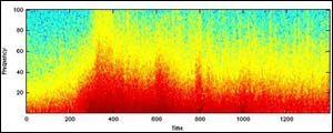
Time After Event Origin Time (seconds)
Researchers Track Underwater Noise Generated by December 26 Earthquake
When the sea floor off the coast of Sumatra split on the morning of December 26, 2004, it took days to measure the full extent of the rupture. Recently, researchers at Columbia University’s Lamont-Doherty Earth Observatory analyzed recordings of the underwater sound produced by the magnitude 9.3 earthquake. Their unique approach enabled them to track the rupture as it moved along the Sumatra-Andaman Fault, raising the possibility that scientists could one day use the method to track underwater earthquakes in near real time and opening new avenues in seismologic research.
“We were able to constrain some details such as the speed and duration of the rupture more accurately than traditional seismic methods,” said Maya Tolstoy, a Doherty Research Scientist and lead author of the study. “Moreover, we found the earthquake happened in two distinct phases, with faster rupture to the south and slower to the north, almost as if there were two back-to-back events.” The study appears in the July/August edition of Seismological Research Letters.
The researchers found that the first phase encompassed the first three minutes of the eight-minute earthquake, during which the rupture proceeded north at about 1.7 miles per second (2.8 km/sec) from the epicenter. During the second phase, the rupture slowed to 1.3 miles per second (2.1 km/sec) and continued north for another five minutes until it reached a plate boundary where the fault changes from subduction to strike-slip. This suggests that had the subduction zone continued, this longest-ever-recorded earthquake might have been even longer.
The analysis that Tolstoy and her co-author DelWayne Bohnenstiehl used also shows promise for helping officials quickly determine where relief activities are needed. In the case of the Indonesian earthquake, early seismic data indicated that only the southernmost third of the fault was involved. Later analysis revealed that about 750 miles actually ruptured, a finding that was supported by Tolstoy and Bohnenstiehl’s study.
Recently the International Monitoring System of the Comprehensive Nuclear Test Ban Treaty, which operates the microphones that picked up sounds of the earthquake, began making their data available on a trial basis to tsunami warning organizations recognized by UNESCO. Tolstoy hopes that eventually scientists will gain easier access to these data as well, which would help them learn more about the basic processes of the Earth. “There is an opportunity here to make a contribution to international disaster monitoring, as well as help us better understand earthquakes and tsunamis and potentially mitigate these events in the future.” said Tolstoy. “It makes sense to let others listen in.”
About The Lamont-Doherty Earth Observatory
The Lamont-Doherty Earth Observatory, a member of The Earth Institute at Columbia University, is one of the world’s leading research centers seeking fundamental knowledge about the origin, evolution and future of the natural world. More than 200 research scientists study the planet from its deepest interior to the outer reaches of its atmosphere, on every continent and in every ocean. From global climate change to earthquakes, volcanoes, nonrenewable resources, environmental hazards and beyond, Observatory scientists provide a rational basis for the difficult choices facing humankind in the planet’s stewardship. For more information, visit www.ldeo.columbia.edu.
About The Earth Institute at Columbia University
The Earth Institute at Columbia University is the world’s leading academic center for the integrated study of Earth, its environment and society. The Earth Institute builds upon excellence in the core disciplines—earth sciences, biological sciences, engineering sciences, social sciences and health sciences—and stresses cross-disciplinary approaches to complex problems. Through research, training and global partnerships, the Earth Institute mobilizes science and technology to advance sustainable development, while placing special emphasis on the needs of the world’s poor.
Media Contact
All latest news from the category: Earth Sciences
Earth Sciences (also referred to as Geosciences), which deals with basic issues surrounding our planet, plays a vital role in the area of energy and raw materials supply.
Earth Sciences comprises subjects such as geology, geography, geological informatics, paleontology, mineralogy, petrography, crystallography, geophysics, geodesy, glaciology, cartography, photogrammetry, meteorology and seismology, early-warning systems, earthquake research and polar research.


Newest articles

Superradiant atoms could push the boundaries of how precisely time can be measured
Superradiant atoms can help us measure time more precisely than ever. In a new study, researchers from the University of Copenhagen present a new method for measuring the time interval,…

Ion thermoelectric conversion devices for near room temperature
The electrode sheet of the thermoelectric device consists of ionic hydrogel, which is sandwiched between the electrodes to form, and the Prussian blue on the electrode undergoes a redox reaction…

Zap Energy achieves 37-million-degree temperatures in a compact device
New publication reports record electron temperatures for a small-scale, sheared-flow-stabilized Z-pinch fusion device. In the nine decades since humans first produced fusion reactions, only a few fusion technologies have demonstrated…

