TU Delft Produces Unique Quake Images Using GPS
Thanks to extensive GPS measurements and analyses by TU Delft and its scientific partners, unique images showing the development of the earthquake on 26 December 2004 in South East Asia have been created. This is the first time that a quake of such magnitude has been recorded and made visible using GPS. Today, Thursday 14 July 2005, an article on this subject will be published in the scientific journal Nature.
In the past few years, working together with French, Indonesian, Malaysian and Thai researchers and scientists, the Delft Institute of Earth Observation and Space Systems (DEOS) of the Faculty of Aerospace Engineering at TU Delft, has established an extensive network of about 45 scientific GPS stations in South East Asia. These stations play an important role in the research done in the SEAMERGES (South East Asia: Mastering Environmental Research with GEodetic Space techniques) project. SEAMERGES is a cooperative research project between universities in the European Union and the ASEAN (Association of South East Asian Nations).
GPS, currently well known for its use in navigation systems, can also be used to accurately measure movement and deformation of the tectonic plates. To achieve this, the Delft researchers use a special, highly accurate geodetic version of the standard GPS method. The unique GPS measurements in South East Asia collected by the SEAMERGES project enabled the scientists to compute the size and direction of the deformations resulting from the earthquake on 26 December 2004 with an accuracy of a few millimetres.
In January of this year, Delft researchers made the news with images showing the development of the tsunami wave, but not the quake itself. Those images were largely based on measurements of water levels in the area, taken by satellites equipped with radar technology to measure ocean surface levels.
The latest research shows that the well known Thai island of Phuket moved 27 cm directly after the quake, which is more than twice the distance initially predicted. Even thousands of kilometres away, in countries like India and China, displacements were registered. Another important development is that, for the first time, the deformations of the tectonic plates during the ten minutes the quake lasted have been made visible. The DEOS scientists have visualised this in an impressive animation, which can be found at their website (www.deos.tudelft.nl).
Moreover, based on the GPS measurements, a number of new conclusions about the quake have been drawn. The most important conclusion is that the rupture plane was much longer (at least 1000 km) than initially expected, based on seismological measurements (~450 km). This means that the force of the quake was not 9.0, but 9.2 to 9.3 on the Richter scale, approximately twice as strong. Also, a significant increase in the likelihood of earthquakes in the surrounding regions was determined. This was dramatically confirmed by the severe earthquake on 28 March 2005 (near the Indonesian Island of Nias). Thankfully, the consequences of this quake were less severe. The results of this research are a marked example of the importance of good international cooperation.
Tsunami-warning
Belgian scientist Ir. Wim Simons, a researcher in Prof. Boudewijn Ambrosius’ group of Astrodynamics and Satellite Systems, played an important part in this Delft success. He initiated the SEAMERGES project, was co-developer of the GPS-measurement systems and he worked on the collection and analysis of the data. According to Simons, the GPS-measurements in South East Asia are still taking place. “There is lag effect in the deformations. For example, Phuket, directly after the quake, had moved 27 cm, that value has now already increased to about 40 cm.” These follow-up measurements provide important information about the way in which forces within the earth’s crust can decrease in some places and build up again (elsewhere).
Simons and other researchers will investigate the data even further to see if they can find any signs in the measurements taken in the months before the quake that could be used to possibly predict such events in the future. As another challenge for the future, Simons sees the use of GPS for the issuing of fast tsunami-warnings. “If all the stations were to relay their measurements in real-time, which is technically possible, the data could be used to generate a model (of a possible tsunami) within about half an hour. If necessary, a warning could then be issued,” says Simons.
Currently, Dr. Julie Pietrzak and her colleagues at professor Guus Stelling’s section for Environmental Fluid Mechanics of the Faculty of Civil Engineering and Geosciences, are using the GPS measurements to create more accurate computer simulations of the tsunami. This kind of modelling was previously done almost exclusively using seismological data. Simons: “Their first results match the real tsunami well, and this research could lead to better and faster tsunami predictions in the future.”
Media Contact
More Information:
http://www.tudelft.nlAll latest news from the category: Earth Sciences
Earth Sciences (also referred to as Geosciences), which deals with basic issues surrounding our planet, plays a vital role in the area of energy and raw materials supply.
Earth Sciences comprises subjects such as geology, geography, geological informatics, paleontology, mineralogy, petrography, crystallography, geophysics, geodesy, glaciology, cartography, photogrammetry, meteorology and seismology, early-warning systems, earthquake research and polar research.


Newest articles

How 3D printers can give robots a soft touch
Soft skin coverings and touch sensors have emerged as a promising feature for robots that are both safer and more intuitive for human interaction, but they are expensive and difficult…
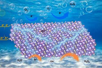
Oxygen vacancies mediated ultrathin Bi4O5Br2 nanosheets
… as efficient piezocatalyst for synthesis of H2O2 from pure water. As an important chemical raw material, hydrogen peroxide (H2O2) is widely applied in various aspects of industry and life….
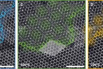
Atom-by-atom: Imaging structural transformations in 2D materials
Silicon-based electronics are approaching their physical limitations and new materials are needed to keep up with current technological demands. Two-dimensional (2D) materials have a rich array of properties, including superconductivity…

