NASA and USGS magnetic database ’rocks’ the world
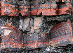
Band Iron Formations <br> <br>These Band Iron formations are precambrian sedimentary rocks. They are highly magnetic. Band Iron Formations like this one were responsible for prominent variations in Earth’s magnetic field, like the Kursk Magnetic Anomaly that was remotely sensed by satellites. Kursk is located in western Russia, at the confluence of the Seym and Tuskar rivers. Credit: Photo courtesy of P.Hoffman <br>
NASA and the United States Geological Survey (USGS) are teaming up to create one of the most complete databases of magnetic properties of Earth’s rocks ever assembled. The partnership demonstrates ongoing interagency collaboration.
Satellite data of Earth’s magnetic field combined with rock magnetic data collected on the ground will provide more complete insight into Earth’s geology, gravity and magnetism.
Satellites, including NASA’s Magsat, have detected magnetic signals in the upper layer of the Earth, called the lithosphere. With over 36,000 rock samples, the combined database will help researchers determine the origin of these signals in Earth’s crust.
The database will be available to the public via the Internet. A clickable map of the world will include locations where detailed rock magnetic data were collected.
Open access to specific properties and locations of each type of rock will allow researchers to more accurately model Earth’s gravity and magnetic fields. This should improve our understanding of the structure and development of Earth’s crust.
“The information in this database will allow more realistic interpretations of satellite magnetic data and will contribute to a variety of studies such as groundwater, mineral resource, and earthquake hazard investigations,” said Katherine Nazarova, a researcher at NASA Goddard Space Flight Center (GSFC) who is coordinating the collaborative effort with Jonathan Glen from the USGS.
The NASA GSFC database contains magnetic properties of 19,000 samples. The samples come from all over the world including the Ukrainian and Baltic shields, Kamchatka, the Ural Mountains and Iceland.
2000 Icelandic rocks in the database have helped explain the source of unusual magnetic activity in Iceland recorded by both Magsat and German Champ missions. Database records revealed the magnetic shifts in Iceland were caused by ferrobasalts, analogues to Martian rocks. As researchers continue to study Mars, these findings may shed light on Mars’ geology.
The USGS database contains rock densities and magnetic properties for some 17,000 entries. Many of these data were taken from surface outcrops in the Western U.S. They span a broad range of rock types.
Researchers collect rock specimens and data in a variety of ways. Research vessels are used to dredge samples from the ocean floor. Ships may also carry huge deep-sea drills that pull cores of sediment and rock from the beneath the ocean. The database includes rock magnetic data from the deepest borehole in the world. It was drilled in northern Russia in the Baltic Shield. Researchers drilled and extracted cores from the continental crust as deep as 12.26 kilometers (7.62 miles).
On land, scientists may collect samples from rock outcrops. When rocks have been exposed to the elements, researchers use small hand drills to uncover fresh material under a rock’s surface.
Satellites that have detected unexplained variations in Earth’s magnetic field include NASA’s Magsat and Polar Orbiting Geophysical Observatory, Germany’s Champ satellite, and the Danish Oersted satellite.
The combined USGS and GSFC databases and future updates will eventually be available and maintained through the National Oceanic and Atmospheric Administration at the World Data Center A in Boulder, Colorado.
Nazarova will present a poster describing the database at the 2004 Joint Assembly of the American Geophysical Union taking place this week in Montreal, Canada.
The mission of NASA’s Earth Science Enterprise is to develop a scientific understanding of the Earth System and its response to natural or human-induced changes to enable improved prediction capability for climate, weather, and natural hazards.
Media Contact
More Information:
http://www.gsfc.nasa.gov/topstory/2004/0517magnet.htmlAll latest news from the category: Earth Sciences
Earth Sciences (also referred to as Geosciences), which deals with basic issues surrounding our planet, plays a vital role in the area of energy and raw materials supply.
Earth Sciences comprises subjects such as geology, geography, geological informatics, paleontology, mineralogy, petrography, crystallography, geophysics, geodesy, glaciology, cartography, photogrammetry, meteorology and seismology, early-warning systems, earthquake research and polar research.


Newest articles

Properties of new materials for microchips
… can now be measured well. Reseachers of Delft University of Technology demonstrated measuring performance properties of ultrathin silicon membranes. Making ever smaller and more powerful chips requires new ultrathin…

Floating solar’s potential
… to support sustainable development by addressing climate, water, and energy goals holistically. A new study published this week in Nature Energy raises the potential for floating solar photovoltaics (FPV)…

Skyrmions move at record speeds
… a step towards the computing of the future. An international research team led by scientists from the CNRS1 has discovered that the magnetic nanobubbles2 known as skyrmions can be…

