Amazon drought now measured from space
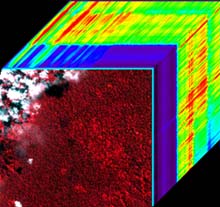
This “data cube” comes from the EO-1 satellite and shows the Amazon forest canopy in the near-infrared on the front of the cube. Uniquely, the shortwave spectrum of every pixel is also shown in the “z direction.” The red on the front indicates the intensity of near-infrared radiation scattering, which is related to the water content of the forest canopy. Each pixel of the image contains a spectral signature that the scientists are analyzing for water, pigments, nitrogen, and other constituents. (Data courtesy NASA; processing and analysis done at Carnegie.)
Using a unique combination of ground-based and space-based tools, scientists have determined for the first time how drought conditions, and possibly carbon uptake, in the Amazon rainforest can be quantified over large forest areas from space. The results are published in the on-line early edition of the Proceedings of the National Academy of Sciences, April 5-9.
“Understanding the Amazon environment is an essential puzzle piece needed to understand how the biosphere interacts with the climate system,” said lead author Dr. Gregory Asner of the Department of Global Ecology at the Carnegie Institution* in Stanford, California. “The Amazon is simply too big and complex to study on the ground alone,” he continued. “Thus far it’s been impossible to determine some of the most basic properties of the forest that we need in order to understand what happens during common climatic events–such as the El Niño dry periods–and what that means to forest growth and the amount of carbon that is locked up in the forest via photosynthesis. Without these measurements we will fall short in understanding how large a role tropical forests play in mediating the effects of fossil-fuel emissions from human activities.”
Amazonia, the world’s largest rainforest, experiences a big range in rainfall from the rainy to dry seasons and during global climatic events such as El Niño. The amount of precipitation affects forest dynamics, land use, and fire susceptibility. To evaluate drought conditions the researchers conducted the first forest canopy experiment in the region. They covered over 10,000 square meters of the central Brazilian Amazon forest with plastic making a “drydown” site and then measured rainfall, soil moisture, leaf and canopy characteristics over time. They coupled these data with a new space-based technology called imaging spectroscopy from the NASA Earth Observing-1 (EO-1) satellite launched in November of 2000. They found that the spectra collected by the satellite from reflected sunlight correlates with on-ground measurements indicating a decrease in soil water and dehydrated leaves.
“The fact that we confirmed that satellite imaging can be used to measure something as detailed as the physiology of the rainforest canopy, means that this technique might be useful for understanding other types of ecological phenomena at both large and small scales,” Asner remarked. ” We believe that space-based technology like this is the wave of the future for analyzing our planet, ” he concluded.
*Other authors include Daniel Nepstad (Woods Hole Research Center and Instituto de Pesquisa Ambiental da Amazonia, Belém, Brazil), Gina Cardinot ( Instituto de Pesquisa Ambiental da Amazonia), and David Ray ( Woods Hole Research Center). This study was supported by NASA, The Mellon Foundation, and the Carnegie Institution.
The Carnegie Institution of Washington (www.CarnegieInstitution.org) has been a pioneering force in basic scientific research since 1902. It is a private, nonprofit organization with six research departments in the U.S.: Embryology, in Baltimore, MD; the Department of Terrestrial Magnetism and the Geophysical Laboratory in Washington, DC; The Observatories in Pasadena, CA, and Chile; and Plant Biology and Global Ecology in Stanford, CA.
Media Contact
More Information:
http://www.ciw.edu/All latest news from the category: Earth Sciences
Earth Sciences (also referred to as Geosciences), which deals with basic issues surrounding our planet, plays a vital role in the area of energy and raw materials supply.
Earth Sciences comprises subjects such as geology, geography, geological informatics, paleontology, mineralogy, petrography, crystallography, geophysics, geodesy, glaciology, cartography, photogrammetry, meteorology and seismology, early-warning systems, earthquake research and polar research.


Newest articles

Properties of new materials for microchips
… can now be measured well. Reseachers of Delft University of Technology demonstrated measuring performance properties of ultrathin silicon membranes. Making ever smaller and more powerful chips requires new ultrathin…

Floating solar’s potential
… to support sustainable development by addressing climate, water, and energy goals holistically. A new study published this week in Nature Energy raises the potential for floating solar photovoltaics (FPV)…

Skyrmions move at record speeds
… a step towards the computing of the future. An international research team led by scientists from the CNRS1 has discovered that the magnetic nanobubbles2 known as skyrmions can be…

