NASA watching Tropical Storm Fabio head to southern California
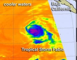
When NASA's Aqua satellite passed over Tropical Storm Fabio on July 16 at 2135 UTC it saw cloud top temperatures were warming (blue) indicating weakening. Sea surface temperature dropped below 22 Celsius (71.6 Fahrenheit). Credit: Credit: NASA JPL, Ed Olsen<br>
When NASA's Aqua satellite passed over Tropical Storm Fabio on July 16 at 2135 UTC (5:35 p.m. EDT), the Atmospheric Infrared Sounder (AIRS) instrument captured temperatures of cloud tops and the sea surface. Cloud top temperatures were warming indicating the strength of uplift in the storm was decreasing and the power was going out of the cyclone.
The weakening trends is a result of ocean temperatures. When AIRS measured the sea surface temperatures around Fabio, they had dropped below 22 Celsius (71.6 Fahrenheit). Sea surface temperatures of 26.6 C (80F) are needed to maintain a tropical cyclone. When Aqua passed over Fabio early on July 17, the AIRS instrument saw the coldest cloud top temperatures were confined to a small area east of the center of circulation, an indication Fabio had weakened more.
On July 17 at 1500 UTC (11 a.m. EDT/8 a.m. PDT), Tropical Storm Fabio had maximum sustained winds near 45 mph (75 kmh). Fabio was located near latitude 22.3 north and longitude 120.5 west. Fabio is moving toward the north near 12 mph (19 kmh). The National Hurricane Center expects Fabio to turn to the north-northeast during the night-time hours on July 17. Additional weakening is forecast and the National Hurricane Center expects Fabio to fizzle to a remnant low pressure area overnight or on Wednesday, July 18.
Despite the weakening trend in Fabio, regional warnings are in effect for the coasts of Baja California and southern California. Fabio is generating large swells, ripe tides and dangerous surf conditions. In addition to rough surf, Fabio is expected to have a wet impact on southern California. The Los Angeles area is expected to see some effects from Hurricane Fabio, according to the local National Weather Service Office there.
Fabio's remnants will bring a chance for some showers and thunderstorms on Wednesday, July 18. Hurricane Fabio's remnants are expected to impact the San Diego area late Wednesday through early Thursday, according to the National Weather Service (NWS). The NWS weather discussion today, July 17, noted, “Mid and high level moisture from the remnants of hurricane Fabio will move northward across the area bringing a slight chance of showers and thunderstorms.”
Media Contact
More Information:
http://www.nasa.govAll latest news from the category: Earth Sciences
Earth Sciences (also referred to as Geosciences), which deals with basic issues surrounding our planet, plays a vital role in the area of energy and raw materials supply.
Earth Sciences comprises subjects such as geology, geography, geological informatics, paleontology, mineralogy, petrography, crystallography, geophysics, geodesy, glaciology, cartography, photogrammetry, meteorology and seismology, early-warning systems, earthquake research and polar research.


Newest articles

Silicon Carbide Innovation Alliance to drive industrial-scale semiconductor work
Known for its ability to withstand extreme environments and high voltages, silicon carbide (SiC) is a semiconducting material made up of silicon and carbon atoms arranged into crystals that is…

New SPECT/CT technique shows impressive biomarker identification
…offers increased access for prostate cancer patients. A novel SPECT/CT acquisition method can accurately detect radiopharmaceutical biodistribution in a convenient manner for prostate cancer patients, opening the door for more…

How 3D printers can give robots a soft touch
Soft skin coverings and touch sensors have emerged as a promising feature for robots that are both safer and more intuitive for human interaction, but they are expensive and difficult…

