NASA watching 2 areas in the Caribbean, 1 is a rainmaker
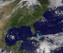
This visible image of System 93L (left) east-southeast of Brownsville, Texas and a larger area of low pressure located a couple hundred miles south of Jamaica (bottom right) was taken from the GOES-13 satellite on June 3 at 1731 UTC (1:31 p.m. EDT). The Jamaican low is expected to be a big rainmaker. Credit: Credit: NASA/NOAA GOES Project, Dennis Chesters<br>
There are two low pressure areas in the Caribbean Sea for future development into tropical cyclones, although the chances are near zero for one, and minimal for the other. The GOES-13 satellite has been following the life of System 93L, which is one of those systems. The second low pressure area may not develop over the weekend, but threatens heavy rain in Hispaniola, Cuba and Jamaica.
The GOES-13 satellite provides images of the U.S. east coast, Atlantic and Caribbean Sea continually every day. In an image from 1731 UTC (1:31 p.m. EDT) today, June 3, the low pressure area known as System 93L is located in the far western Caribbean Sea. It appears as a small area of cloudiness, about 275 miles east-southeast of Brownsville, Texas. GOES-13 has been tracking that low pressure area for over a week, since it developed off the North Carolina coast and tracked across Florida last weekend and into the Gulf of Mexico.
Wind shear will continue to prevent System 93L from developing further over the weekend, so there's a “near zero percent chance” it will develop in the next 48 hours, according to the National Hurricane Center. System 93L now appears to be moving northwestward between 10 and 15 mph after tracking southward earlier this week.
A second low pressure area is also catching the eye of forecasters who use GOES-13 satellite data. The second low is located a couple hundred miles south of Jamaica and has become a little better defined today. That low pressure area appears to dwarf System 93L in size, as the center of circulation is surrounded by a large area of cloudiness.
One factor that keeps that low's chance for development down to 20% this weekend is the movement of dry air into its western side. Dry air prevents formation of the thunderstorms that power a tropical cyclone.
Despite the low chances for development, however, this low is expected to bring heavy rainfall, flash flooding and mudslides over portions of Jamaica, Haiti, the Dominican Republic and southeastern Cuba over the next couple of days. That low is forecast to remain almost stationary over the west-central Caribbean Sea for the next couple of days.
The image of both low pressure areas was created by the NASA/NOAA GOES Project at NASA's Goddard Space Flight Center in Greenbelt, Md. The series of Geostationary Operational Environmental Satellites (GOES) are managed by NOAA, and the NASA/NOAA GOES Project creates images and animations from those satellites.
Media Contact
More Information:
http://www.nasa.govAll latest news from the category: Earth Sciences
Earth Sciences (also referred to as Geosciences), which deals with basic issues surrounding our planet, plays a vital role in the area of energy and raw materials supply.
Earth Sciences comprises subjects such as geology, geography, geological informatics, paleontology, mineralogy, petrography, crystallography, geophysics, geodesy, glaciology, cartography, photogrammetry, meteorology and seismology, early-warning systems, earthquake research and polar research.


Newest articles

Properties of new materials for microchips
… can now be measured well. Reseachers of Delft University of Technology demonstrated measuring performance properties of ultrathin silicon membranes. Making ever smaller and more powerful chips requires new ultrathin…

Floating solar’s potential
… to support sustainable development by addressing climate, water, and energy goals holistically. A new study published this week in Nature Energy raises the potential for floating solar photovoltaics (FPV)…

Skyrmions move at record speeds
… a step towards the computing of the future. An international research team led by scientists from the CNRS1 has discovered that the magnetic nanobubbles2 known as skyrmions can be…

