NASA watches as Tropical Storm Bolaven develops
NASA's Aqua satellite has been monitoring the birth and progress of Tropical Storm Bolaven in the western North Pacific from Aug. 19-20. The AIRS instrument has provided infrared satellite imagery that shows the development of colder thunderstorm cloud-top temperatures that were indicative of strengthening storms.<br><br>Credit: NASA JPL, Ed Olsen<br>
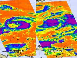
NASA's Aqua satellite has been monitoring the birth and progress of Tropical Storm Bolaven in the western North Pacific from Aug 19-20, 2012. The Atmospheric Infrared Sounder (AIRS) instrument has provided infrared satellite imagery that shows the development of colder thunderstorm cloud-top temperatures, that were indicative of strengthening storms. Tropical Storm Bolaven also took more of a rounded shape on August 20 as it continued to organize and intensify.
On August 19 at 03:11 UTC (Aug. 18 at 11:11 p.m. EDT) the AIRS image of Bolaven appeared loosely organized. At that time, the strongest thunderstorms appeared to be east of the center of circulation.
On August 20 at 3:53 UTC (Aug. 19 11:53 p.m. EDT), NASA's AIRS instrument on the Aqua satellite captured another infrared image of Bolaven. The infrared AIRS image showed the storm had a much tighter circulation and Bolaven's strongest thunderstorms were south of the center of circulation, where cloud top temperatures were colder than -63 Fahrenheit (-52 Celsius). Hours later, Bolaven was located about 400 nautical miles (460 miles/741 km) south of Iwo To, Japan, near 18.2 North latitude and 141.2 West longitude. It was moving to the north-northwest at 5 knots (5.7 mph/9.2 kmh) and had maximum sustained winds near 35 knots (40 mph/65 kmh).
Bolaven will continue strengthening as it moves to the west-northwest over the next couple of days in open waters of the western North Pacific Ocean. By August 24 forecasters at the Joint Typhoon Warning Center expect Bolaven to reach typhoon status.
Media Contact
More Information:
http://www.nasa.govAll latest news from the category: Earth Sciences
Earth Sciences (also referred to as Geosciences), which deals with basic issues surrounding our planet, plays a vital role in the area of energy and raw materials supply.
Earth Sciences comprises subjects such as geology, geography, geological informatics, paleontology, mineralogy, petrography, crystallography, geophysics, geodesy, glaciology, cartography, photogrammetry, meteorology and seismology, early-warning systems, earthquake research and polar research.


Newest articles

Peptides on Interstellar Ice
A research team led by Dr Serge Krasnokutski from the Astrophysics Laboratory at the Max Planck Institute for Astronomy at the University of Jena had already demonstrated that simple peptides…

A new look at the consequences of light pollution
GAME 2024 begins its experiments in eight countries. Can artificial light at night harm marine algae and impair their important functions for coastal ecosystems? This year’s project of the training…

Silicon Carbide Innovation Alliance to drive industrial-scale semiconductor work
Known for its ability to withstand extreme environments and high voltages, silicon carbide (SiC) is a semiconducting material made up of silicon and carbon atoms arranged into crystals that is…

