NASA Spies Fifth Atlantic Hurricane and Twelfth Tropical Depression
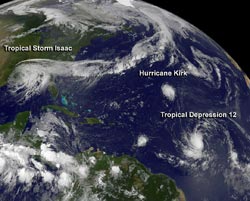
This visible image of Tropical Storm Isaac over the U.S. Gulf coast, Hurricane Kirk and Tropical Depression 12 in the central Atlantic Ocean. The image was taken from NOAA's GOES-13 satellite on Aug. 30 at 7:45 a.m. EDT.<br>Credit: NASA GOES Project <br>
On Aug. 30 at 7:45 a.m. EDT, a visible image from NOAA's GOES-13 satellite captured all three tropical cyclones in a panoramic shot of the Atlantic Ocean basin. The visible image showed Tropical Storm Isaac over the U.S. Gulf coast, Hurricane Kirk and Tropical Depression 12 in the central Atlantic Ocean. Isaac was by far the largest of the three systems, with cloud cover extending from east Texas to the Carolinas. Hurricane Kirk appeared as a small, rounded , compact storm, located northwest of newborn Tropical Depression 12, which appeared larger than Kirk. The image was created by the NASA GOES Project at the NASA Goddard Space Flight Center in Greenbelt, Md.
Hurricane Kirk
At 11 a.m. EDT on Aug. 30, Kirk became the fifth hurricane of the Atlantic Ocean season. Its maximum sustained winds were near 75 mph (120 kmh). It was far from land, however, about 1.065 miles (1.715) northeast of the Northern Leeward Islands near 27.2 North and 49.5 West. It was moving to the northwest at 12 mph (19 kmh) and had a minimum central pressure of 989 millibars. The GOES-13 image showed that Kirk was a compact hurricane, and hurricane-force winds only extend 10 miles (20 km) from the center, while tropical-storm-force winds extend up to 70 miles (110 km).
Tropical Depression 12 Expected to Become Tropical Storm Leslie
On Aug. 30 at 11 a.m. the warm summertime waters of the Atlantic Ocean gave birth to the twelfth tropical depression on the season. Tropical Depression 12 (TD12) had maximum sustained winds near 35 mph (55 km/h), and is expected to become a tropical storm later on Aug. 30 and could become a hurricane over the weekend, according to the National Hurricane Center.
TD12 was also far from land areas, located about 1,185 miles (1,905 km) east of the Windward Islands, near latitude 14.1 north and longitude 43.4 west. TD12 is moving quickly to the west near 20 mph (32 kmh). TD12's estimated minimum central pressure is 1007 millibars.
Satellite data shows a well-defined curved band of thunderstorms wrapping around the western side of the circulation center.TD12 is expected to move over warm waters which will help it strengthen, and it could become Tropical Storm Leslie later on Aug. 30,or Hurricane Leslie by the weekend of Sept. 2.
Text Credit: Rob Gutro
NASA Goddard Space Flight Center, Greenbelt, Md.
Media Contact
All latest news from the category: Earth Sciences
Earth Sciences (also referred to as Geosciences), which deals with basic issues surrounding our planet, plays a vital role in the area of energy and raw materials supply.
Earth Sciences comprises subjects such as geology, geography, geological informatics, paleontology, mineralogy, petrography, crystallography, geophysics, geodesy, glaciology, cartography, photogrammetry, meteorology and seismology, early-warning systems, earthquake research and polar research.


Newest articles

“Nanostitches” enable lighter and tougher composite materials
In research that may lead to next-generation airplanes and spacecraft, MIT engineers used carbon nanotubes to prevent cracking in multilayered composites. To save on fuel and reduce aircraft emissions, engineers…

Trash to treasure
Researchers turn metal waste into catalyst for hydrogen. Scientists have found a way to transform metal waste into a highly efficient catalyst to make hydrogen from water, a discovery that…

Real-time detection of infectious disease viruses
… by searching for molecular fingerprinting. A research team consisting of Professor Kyoung-Duck Park and Taeyoung Moon and Huitae Joo, PhD candidates, from the Department of Physics at Pohang University…

