NASA: How do you solve a problem like (Tropical Storm) Maria?
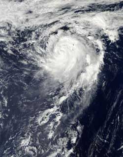
The MODIS instrument aboard NASA's Aqua satellite captured this visible image of Tropical Storm Maria in the northwestern Pacific Ocean on Oct. 16 at 0355 UTC (Oct. 15 at 11:55 p.m. EDT).<br><br>Credit: NASA Goddard MODIS Rapid Response Team<br>
NASA's Aqua satellite passed over Tropical Storm Maria on Oct. 16 at 0355 UTC, 12:55 p.m. local time Tokyo/Japan (Oct. 15 at 11:55 p.m. EDT) and the Moderate Resolution Imaging Spectroradiometer (MODIS) instrument captured a visible image of the storm when it was approaching Iwo To, Japan. The image shows that Maria had a strong circulation with bands of thunderstorms wrapping around the center from the south and east and into the center from the north.
On Oct. 16 at 0900 UTC (5 a.m. EDT), Maria had maximum sustained winds near 55 knots (63.2 mph/102 kph). It had passed Iwo To and was located about 135 nautical miles (155 miles/250 km) north of the island, moving north-northeast at 15 knots (17.2 mph/27.7 kph).
Although increased wind shear and cooler waters would weaken Maria, neither of those factors will be present over the next couple of days as the storm moves to the north-northeast over open waters. In fact, on Oct. 16, a satellite image from NASA's Tropical Rainfall Measuring Mission (TRMM) satellite showed that the center is consolidating and that bands of thunderstorms are more tightly curved around the center. The TRMM data also revealed an eye feature.
Maria is moving around a ridge (elongated area) of high pressure. High pressure circulates in a clockwise direction, and Maria is on the western side of the high, so it will be curving to the northeast as it continues moving around. The Joint Typhoon Warning Center expects that Maria may become extra-tropical in three days.
Media Contact
More Information:
http://www.nasa.govAll latest news from the category: Earth Sciences
Earth Sciences (also referred to as Geosciences), which deals with basic issues surrounding our planet, plays a vital role in the area of energy and raw materials supply.
Earth Sciences comprises subjects such as geology, geography, geological informatics, paleontology, mineralogy, petrography, crystallography, geophysics, geodesy, glaciology, cartography, photogrammetry, meteorology and seismology, early-warning systems, earthquake research and polar research.


Newest articles

Combatting disruptive ‘noise’ in quantum communication
In a significant milestone for quantum communication technology, an experiment has demonstrated how networks can be leveraged to combat disruptive ‘noise’ in quantum communications. The international effort led by researchers…

Stretchable quantum dot display
Intrinsically stretchable quantum dot-based light-emitting diodes achieved record-breaking performance. A team of South Korean scientists led by Professor KIM Dae-Hyeong of the Center for Nanoparticle Research within the Institute for…

Internet can achieve quantum speed with light saved as sound
Researchers at the University of Copenhagen’s Niels Bohr Institute have developed a new way to create quantum memory: A small drum can store data sent with light in its sonic…

