NASA sees withering post-tropical storm Fabio moving toward coast
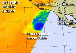
When NASA's Aqua satellite passed over post-tropical storm Fabio on July 18 at 1023 UTC (6:23 a.m. EDT) it detected very little strong convection and heavy rainfall (blue area). Sea surface temperature dropped below 22 Celsius (71.6 Fahrenheit) and can't support a tropical cyclone. Credit: Credit: NASA JPL, Ed Olsen<br>
When NASA's Aqua satellite passed over post-tropical storm Fabio on July 18 at 1023 UTC (6:23 a.m. EDT), the Atmospheric Infrared Sounder (AIRS) instrument captured temperatures of cloud tops and the sea surface. AIRS data showed very little strong convection and heavy rainfall occurring in the post-tropical storm and it was north of the center of circulation. Wind shear from the south is pushing the showers north of the center.
Sea surface temperatures are not warm enough to support a tropical cyclone because they are colder than 22 Celsius (71.6 Fahrenheit) in the area Fabio is moving through.
At 11 a.m. EDT on July 18, the National Hurricane Center issued their final advisory on post-tropical storm Fabio. At that time, Fabio was about 535 miles (855 km) south-southwest of San Diego, California, near latitude 25.7 north and longitude 120.8 west. Fabio's maximum sustained winds were near 30 mph (45 kmh) and weakening. It was still moving to the north at 9 mph (15 kmh) but is expected to turn to the north-northeast.
Doppler radar images from San Diego, Calif. showed some shower activity from Fabio approaching the area at 11 a.m. EDT on July 18.
The National Hurricane Center expects Fabio to dissipate in a couple of days. Meanwhile, large ocean swells, rip tides and dangerous surf conditions continue to affect the coasts of Baja California, Mexico and southern California.
Media Contact
More Information:
http://www.nasa.govAll latest news from the category: Earth Sciences
Earth Sciences (also referred to as Geosciences), which deals with basic issues surrounding our planet, plays a vital role in the area of energy and raw materials supply.
Earth Sciences comprises subjects such as geology, geography, geological informatics, paleontology, mineralogy, petrography, crystallography, geophysics, geodesy, glaciology, cartography, photogrammetry, meteorology and seismology, early-warning systems, earthquake research and polar research.


Newest articles

Security vulnerability in browser interface
… allows computer access via graphics card. Researchers at Graz University of Technology were successful with three different side-channel attacks on graphics cards via the WebGPU browser interface. The attacks…

A closer look at mechanochemistry
Ferdi Schüth and his team at the Max Planck Institut für Kohlenforschung in Mülheim/Germany have been studying the phenomena of mechanochemistry for several years. But what actually happens at the…

Severe Vulnerabilities Discovered in Software to Protect Internet Routing
A research team from the National Research Center for Applied Cybersecurity ATHENE led by Prof. Dr. Haya Schulmann has uncovered 18 vulnerabilities in crucial software components of Resource Public Key…

