NASA Sees Wind Shear Battering Tropical Storm Nadine
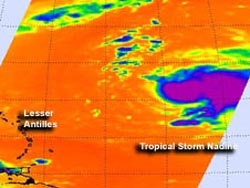
NASA's Aqua satellite passed over Tropical Storm Nadine on Sept. 13 at 01:23 a.m. EDT. AIRS infrared data found the strongest thunderstorms (purple) with very cold cloud temperatures being pushed east of the center by wind shear. Credit: NASA/JPL, Ed Olsen<br>
NASA's Aqua satellite passed over Tropical Storm Nadine early on Sept. 13 and saw several factors that indicated the storm was still struggling to achieve hurricane status.
Infrared data from the Atmospheric Infrared Sounder (AIRS) that flies aboard Aqua found the strongest thunderstorms with very cold cloud temperatures (colder than -63F/-52C) were being pushed east of Nadine's center by wind shear.
Although Nadine is expected to reach hurricane status later on Sept.13 or Sept. 14, the storm did not yet develop an eye. The AIRS infrared image also showed that Nadine's cloud pattern was not symmetric, and a tropical cyclone needs symmetry to intensify. If the moderate southwesterly wind shear relaxes, Nadine will have a better chance of intensifying. Satellite data also suggests that intrusion of mid-level dry air, which is also sapping Nadine's strength.
At 11 a.m. EDT on Sept. 13, Tropical Storm Nadine's maximum sustained winds were just under hurricane strength, near 70 mph (110 kmh). The National Hurricane Center noted that Nadine could become a hurricane later on Sept. 13 (today). The center of Tropical Storm Nadine was located near latitude 22.6 north and longitude 52.2 west, about 770 miles (1,235 km) east-northeast of the Northern Leeward Islands. Nadine is moving toward the northwest near 16 mph (26 kmh) and the National Hurricane Center expects Nadine to turn to the north-northwest and later to the north.
Text credit: Rob Gutro
NASA's Goddard Space Flight Center, Greenbelt, Md.
Media Contact
All latest news from the category: Earth Sciences
Earth Sciences (also referred to as Geosciences), which deals with basic issues surrounding our planet, plays a vital role in the area of energy and raw materials supply.
Earth Sciences comprises subjects such as geology, geography, geological informatics, paleontology, mineralogy, petrography, crystallography, geophysics, geodesy, glaciology, cartography, photogrammetry, meteorology and seismology, early-warning systems, earthquake research and polar research.


Newest articles

Superradiant atoms could push the boundaries of how precisely time can be measured
Superradiant atoms can help us measure time more precisely than ever. In a new study, researchers from the University of Copenhagen present a new method for measuring the time interval,…

Ion thermoelectric conversion devices for near room temperature
The electrode sheet of the thermoelectric device consists of ionic hydrogel, which is sandwiched between the electrodes to form, and the Prussian blue on the electrode undergoes a redox reaction…

Zap Energy achieves 37-million-degree temperatures in a compact device
New publication reports record electron temperatures for a small-scale, sheared-flow-stabilized Z-pinch fusion device. In the nine decades since humans first produced fusion reactions, only a few fusion technologies have demonstrated…

