NASA sees Typhoon Nesat nearing landfall in northern Philippines
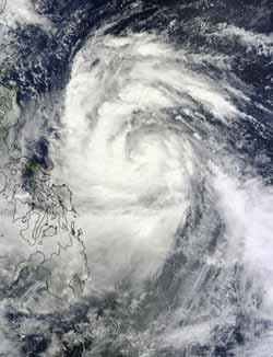
This visible image of Typhoon Nesat was captured by the MODIS instrument on Sunday, Sept. 25, at 2:40 UTC as its western edges began to spread over the Philippines. Nesat's eye is not visible in this image. Credit: NASA Goddard MODIS Rapid Response Team<br>
NASA's Terra satellite flew over Typhoon Nesat yesterday. Nesat is known locally in the Philippines as “Pedring.” NASA's Moderate Resolution Imaging Spectroradiometer (MODIS) captured a visible image of the large storm on Sunday, Sept. 25 at 2:40 UTC (10:40 a.m. local time/Philippines) as its western edges began to spread over the Philippines. Although the visible image did not reveal an eye because it was cloud-filled, satellite microwave imagery did spot the eye.
Typhoon Nesat has maximum sustained winds near 80 knots (92 mph/148 kmh) on Monday, Sept. 26 as its center approaches northern Luzon, Philippines. It was located only 225 miles east-northwest of Manila, near 15.9 North and 124.2 East. It was moving to the west-northwest near 14 knots (16 mph/26 kmh).
Satellite imagery shows tightly-curved bands of thunderstorms wrapping into the low level center of circulation. That's an indication the storm is well-organized. The strongest convection and thunderstorms are mostly over the western semi-circle of the storm today. Microwave satellite data does reveal Nesat has an eye which helps forecasters pinpoint Nesat's center.
PAGASA, the Philippines' meteorological service expects Nesat (Pedring) will make landfall Tuesday afternoon (local time/Philippines) over Casiguran, Aurora and will be in the vicinity of Baguio City. Coastal areas can expect dangerous surf and high ocean swells, heavy rainfall and gusty winds.
Many watches and warnings are in effect. A Signal 3 (for the strongest winds) has been posted for: Catanduanes, Camarines Sur, Camarines Norte, Northern Quezon, Polillo Island, Aurora, Quirino and Isabela. Signal 2 is in effect for Albay, Burias Island, Sorsogon, Rest of Quezon, Rizal, Bulacan, Nueva Ecija, Nueva Vizcaya, Ifugao, Benguet, Mt. Province, Kalinga, Cagayan and Metro Manila. Signal 1 has been raised for Ticao Island, Masbate, Marinduque, Batangas, Cavite, Bataan, Laguna, Pampanga, Zambales, Tarlac, Pangasinan, La Union, Ilocos Sur, Ilocos Norte, Abra, Apayao, Calayan, and the Babuyan Group of Islands.
The Joint Typhoon Warning Center forecasts Nesat to continue tracking due west over Luzon and make landfall with maximum sustained winds near 90 knots (103 mph/166 kmh). It is forecast to cross Luzon and move into the South China Sea in one day.
Media Contact
More Information:
http://www.nasa.govAll latest news from the category: Earth Sciences
Earth Sciences (also referred to as Geosciences), which deals with basic issues surrounding our planet, plays a vital role in the area of energy and raw materials supply.
Earth Sciences comprises subjects such as geology, geography, geological informatics, paleontology, mineralogy, petrography, crystallography, geophysics, geodesy, glaciology, cartography, photogrammetry, meteorology and seismology, early-warning systems, earthquake research and polar research.


Newest articles

Properties of new materials for microchips
… can now be measured well. Reseachers of Delft University of Technology demonstrated measuring performance properties of ultrathin silicon membranes. Making ever smaller and more powerful chips requires new ultrathin…

Floating solar’s potential
… to support sustainable development by addressing climate, water, and energy goals holistically. A new study published this week in Nature Energy raises the potential for floating solar photovoltaics (FPV)…

Skyrmions move at record speeds
… a step towards the computing of the future. An international research team led by scientists from the CNRS1 has discovered that the magnetic nanobubbles2 known as skyrmions can be…

