NASA Sees Typhoon Halong's Eye Wink
On August 4 at 12:40 a.m. EDT NASA's Aqua satellite captured this visible image of Typhoon Halong and its cloud-filled eye as it continued tracking north toward Japan. Image Credit: NASA Goddard MODIS Rapid Response Team
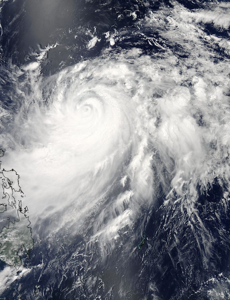
On August 2 at 01:45 UTC (August 1 at 9:45 p.m. EDT) NASA's Terra satellite captured a visible image of a wide-eyed Super Typhoon Halong moving through the Northwestern Pacific Ocean. At the time of the image, Halong was a powerful Category 5 Super Typhoon on the Saffir-Simpson Scale. Satellite data showed that Halong had a 10-nautical mile (11.5 mile/18.5 km) wide eye.
On August 4 at 04:40 UTC (12:40 a.m. EDT), NASA's Aqua satellite captured a visible image of Super Typhoon Halong that showed its eye had become cloud filled. The image also showed that the bulk of strongest bands of thunderstorms were over the southern quadrant of the storm.
Forecasters at the Joint Typhoon Warning Center or JTWC noted that microwave satellite imagery suggests an on-going eyewall replacement. That's when the thunderstorms that circle the eye of a powerful hurricane are replaced by other thunderstorms. Basically, a new eye begins to develop around the old eye.
Many intense hurricanes undergo at least one of these eyewall replacements during their existence. JTWC noted that the eyewall replacement correlates to the recent weakening trend.
On Monday, August 4, Super Typhoon Halong's maximum sustained winds had dropped to near 105 knots (120.8 mph/190.4 kph), making it a Category Two hurricane on the Saffir-Simpson Scale. On August 3, Halong was a Super Typhoon with maximum sustained winds near 130 knots (149.6 mph/240.8 kph) on August 3, which made it a Category Four storm.
On August 4, Halong was centered near 17.3 north and 130.3 east, about 588 nautical miles (676.7 miles/1,089 km) south-southeast of Kadena Air Base, Okinawa, Japan. Halong was moving northwest at 4 knots (4.6 mph/7.4 kph). Because Halong is such a powerful storm, it is generating extremely rough seas. The Joint Typhoon Warning Center noted that wave heights were near 42 feet (12.8 meters).
The JTWC expects Halong to continue moving in a northerly direction for the next couple of days.
Text credit: Rob Gutro
NASA's Goddard Space Flight Center
Media Contact
More Information:
http://www.nasa.gov/content/goddard/11w-northwestern-pacific-ocean/All latest news from the category: Earth Sciences
Earth Sciences (also referred to as Geosciences), which deals with basic issues surrounding our planet, plays a vital role in the area of energy and raw materials supply.
Earth Sciences comprises subjects such as geology, geography, geological informatics, paleontology, mineralogy, petrography, crystallography, geophysics, geodesy, glaciology, cartography, photogrammetry, meteorology and seismology, early-warning systems, earthquake research and polar research.


Newest articles

Silicon Carbide Innovation Alliance to drive industrial-scale semiconductor work
Known for its ability to withstand extreme environments and high voltages, silicon carbide (SiC) is a semiconducting material made up of silicon and carbon atoms arranged into crystals that is…

New SPECT/CT technique shows impressive biomarker identification
…offers increased access for prostate cancer patients. A novel SPECT/CT acquisition method can accurately detect radiopharmaceutical biodistribution in a convenient manner for prostate cancer patients, opening the door for more…

How 3D printers can give robots a soft touch
Soft skin coverings and touch sensors have emerged as a promising feature for robots that are both safer and more intuitive for human interaction, but they are expensive and difficult…

