NASA Sees Tropical Storm Unala Develop and Weaken Quickly
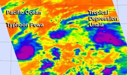
Cloud top temperatures in thunderstorms circling Tropical Storm Unala's (right) center on Aug. 19 at 0105 UTC were colder than -63F/-52C, indicating strong storms with heavy rain potential. Typhoon Pewa's (left) cloud tops were colder. Image Credit: NASA JPL, Ed Olsen <br>
Aqua captured an image of Tropical Storm Unala in the central Pacific Ocean where it formed early today, Aug. 19. Over several hours, Unala moved into the northwestern Pacific where it quickly weakened to a depression.
NASA's Aqua satellite caught Unala in the same image as Typhoon Storm Pewa, which is responsible for Unala's quick weakening. The two tropical cyclones are just 184 nautical miles apart and are expected to be just 60 miles from each other later today (Aug. 19).
The Atmospheric Infrared Sounder or AIRS instrument captures infrared data and scientists are able to measure cloud top temperatures of storms, and surrounding sea surface temperatures: two factors that are important in understanding what's happening or will happen with tropical cyclones.
Tropical cyclones need sea surface temperatures of at least 26.6C/80F to survive and thrive, and temperatures in the vicinity of Tropical Depression Unala are at least that warm. Cloud top temperatures in the thunderstorms that make up tropical cyclones tell scientists how high the cloud tops are in the troposphere, and the higher the storm, the colder it is, and the stronger it is.
Cloud top temperatures in thunderstorms circling Unala's center early on Aug. 19 were around -63F/-52C, indicating there were some strong storms with heavy rain potential, but those cloud tops warmed later in the day, indicating weakening. Storms in nearby Pewa showed colder temperatures, and Pewa has since become a typhoon.
At 1500 UTC/11 a.m. EDT on Aug. 19, Tropical Depression Unala had maximum sustained winds near 30 knots/34.5 mph/55.5 kph, after peaking earlier in the day at 40 mph/65 kph. The center of Unala was located near latitude 17.3 north, longitude 178.1 west, about 705 nautical miles east of Wake Island. The estimated minimum central pressure is 1008 millibars. Unala was moving toward the west near 20 mph/32 kph, and this general motion is expected to continue for the next day.
Forecasters at the Central Pacific Hurricane Center noted that the interaction between Unala and Typhoon Pewa is expected to cause Unala to weaken more and dissipate within 24 hours.
Text credit: Rob Gutro
NASA's Goddard Space Flight Center
Media Contact
All latest news from the category: Earth Sciences
Earth Sciences (also referred to as Geosciences), which deals with basic issues surrounding our planet, plays a vital role in the area of energy and raw materials supply.
Earth Sciences comprises subjects such as geology, geography, geological informatics, paleontology, mineralogy, petrography, crystallography, geophysics, geodesy, glaciology, cartography, photogrammetry, meteorology and seismology, early-warning systems, earthquake research and polar research.


Newest articles

Bringing bio-inspired robots to life
Nebraska researcher Eric Markvicka gets NSF CAREER Award to pursue manufacture of novel materials for soft robotics and stretchable electronics. Engineers are increasingly eager to develop robots that mimic the…

Bella moths use poison to attract mates
Scientists are closer to finding out how. Pyrrolizidine alkaloids are as bitter and toxic as they are hard to pronounce. They’re produced by several different types of plants and are…

AI tool creates ‘synthetic’ images of cells
…for enhanced microscopy analysis. Observing individual cells through microscopes can reveal a range of important cell biological phenomena that frequently play a role in human diseases, but the process of…

