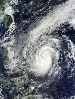
NASA sees Tropical Storm Krosa approach the Philippines

On Oct. 30 at 02:10 UTC, NASA's Terra satellite captured this visible image of Tropical Storm Krosa east of the Philippines.<br><br>Credit: NASA Goddard MODIS Rapid Response Team<br>
Several warnings have been issued by PAGASA for areas of the Philippines. Signal No. 2 is in effect for area in Luzon. Signal 2 means winds of 37.2 to 62 mph/60 to 100 kph are likely in at least 24 hours. Areas under Signal 2 include: Cagayan, the Calayan group of islands, the Babuyan group of islands, Isabela, Kalinga, Apayao, Ilocos Norte, Ilocos Sur, Abra and Mt. Province.
There is also a signal 1 in effect for parts of Luzon. Signal 1 means winds of 18.6 to 37.2 mph/30 to 60 kph are likely in at least 36 hours. Signal 1 is in effect for the following areas: La Union, Pangasinan, Benguet, Ifugao, Nueva Vizcaya, Nueva Ecija, Quirino, Aurora and the Batanes group of islands.
On Oct. 30 at 02:10 UTC, the Moderate Resolution Imaging Spectroradiometer instrument aboard NASA's Terra satellite captured a visible image of Tropical Storm Krosa east of the Philippines, and showed bands of thunderstorms were wrapping into the center from the north and south of the center. Krosa had not yet developed an eye, but the storm was intensifying.
The Atmospheric Infrared Sounder instrument called AIRS that flies aboard NASA's Aqua satellite captured data on Oct. 30 at 0511 UTC/1:11 a.m. EDT. AIRS data showed strong thunderstorms wrapped tightly around Krosa's center, and in bands of thunderstorms feeding into the center. At 1059 UTC/6:59 a.m. EDT, microwave data also revealed that an eye was forming.
On Oct. 30 at 1500 UTC/11 a.m. EDT, Krosa had maximum sustained winds near 60 knots/69 mph/111.1 kph. Its center was located near 17.3 north latitude and 126.3 east longitude, about 374 nautical miles east-northeast of Manila, Philippines. It was moving to the west at 14 knots/16.1 mph/25.9 kph. The warm sea surface temperatures of the Philippine Sea are expected to enable Krosa to reach typhoon status before it makes landfall.
Krosa is forecast to make a brief landfall over extreme northern Luzon on Oct. 31 before moving west into the South China Sea. Once there, it is expected to brush Hainan Island, China and make a final landfall in Vietnam sometime on Nov. 4, according to the Joint Typhoon Warning Center forecast.
Media Contact
More Information:
http://www.nasa.govAll latest news from the category: Earth Sciences
Earth Sciences (also referred to as Geosciences), which deals with basic issues surrounding our planet, plays a vital role in the area of energy and raw materials supply.
Earth Sciences comprises subjects such as geology, geography, geological informatics, paleontology, mineralogy, petrography, crystallography, geophysics, geodesy, glaciology, cartography, photogrammetry, meteorology and seismology, early-warning systems, earthquake research and polar research.
Newest articles

Security vulnerability in browser interface
… allows computer access via graphics card. Researchers at Graz University of Technology were successful with three different side-channel attacks on graphics cards via the WebGPU browser interface. The attacks…

A closer look at mechanochemistry
Ferdi Schüth and his team at the Max Planck Institut für Kohlenforschung in Mülheim/Germany have been studying the phenomena of mechanochemistry for several years. But what actually happens at the…

Severe Vulnerabilities Discovered in Software to Protect Internet Routing
A research team from the National Research Center for Applied Cybersecurity ATHENE led by Prof. Dr. Haya Schulmann has uncovered 18 vulnerabilities in crucial software components of Resource Public Key…


