NASA sees Tropical Storm Julia born with strong thunderstorms and heavy rainfall
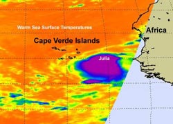
NASA\'s Aqua satellite captured an infrared image of Tropical Depression 12 early on Sept. 12 when it was just east-southeast of the Cape Verde Islands. At that time it showed strong convection and powerful thunderstorms around its center (purple). By 11 p.m. EDT that day it became Tropical Storm Julia. Warm sea surface temperatures of 80F or higher (orange) surround Julia.<br><br>Credit: NASA/JPL, Ed Olsen<br>
The Atmospheric Infrared Sounder (AIRS) instrument that flies on NASA's Aqua satellite gives scientists and meteorologists clues about how a tropical cyclone is behaving by providing critical temperature data.
When Aqua flew over Tropical Depression 12 early on Sept. 12 the concentration of strong convection (rapidly rising air that forms thunderstorms that power a tropical cyclone) were large and surrounded the depression's center. Cloud top temperatures over a large area were as cold or colder than -63 degrees Fahrenheit, and those thunderstorms were strong. The convection continued on Sept. 12 and the storm finally strengthened into Tropical Storm Julia.
The Tropical Rainfall Measuring Mission (TRMM) satellite, which is operated jointly by NASA and the Japanese Space Agency, JAXA captured a very good daytime look at Julia when she was tropical depression 12 on September 12 at 1822 UTC (2:22p.m. EDT). TRMM showed that TD12 was starting to get organized and had moderate to very heavy rainfall converging into the center of the future storm's circulation. Julia is another in a series of 2010 tropical cyclones forming near the Cape Verde Islands off the African Coast.
Tropical Storm Julia is moving away from the southernmost Cape Verde Islands today, Sept. 13, but not before she lashes them with winds and rain. Tropical storm force winds in squalls are expected over parts of the southernmost Cape Verde Islands this morning and diminish later today. In addition, much of the Cape Verde islands can expect 2 to 4 inches of rainfall with higher totals in isolated areas.
She was “born” on Sept. 12 at around 11 a.m. EDT near 12.7 North and 21.4 West. Since then, she's moved west to 14.5 North and 25.6 West, which is about 85 miles west-southwest of the southernmost Cape Verde Islands. Her maximum sustained winds are near 40 mph, and is expected to strengthen in the next couple of days, possibly reaching hurricane status. Julia is moving west-northwest near 14 mph and had a minimum central pressure of 1004 millibars.
Julia is expected to continue moving west-northwest, then turn northwest and slow down tomorrow.
Media Contact
More Information:
http://www.Nasa.govAll latest news from the category: Earth Sciences
Earth Sciences (also referred to as Geosciences), which deals with basic issues surrounding our planet, plays a vital role in the area of energy and raw materials supply.
Earth Sciences comprises subjects such as geology, geography, geological informatics, paleontology, mineralogy, petrography, crystallography, geophysics, geodesy, glaciology, cartography, photogrammetry, meteorology and seismology, early-warning systems, earthquake research and polar research.


Newest articles

Bringing bio-inspired robots to life
Nebraska researcher Eric Markvicka gets NSF CAREER Award to pursue manufacture of novel materials for soft robotics and stretchable electronics. Engineers are increasingly eager to develop robots that mimic the…

Bella moths use poison to attract mates
Scientists are closer to finding out how. Pyrrolizidine alkaloids are as bitter and toxic as they are hard to pronounce. They’re produced by several different types of plants and are…

AI tool creates ‘synthetic’ images of cells
…for enhanced microscopy analysis. Observing individual cells through microscopes can reveal a range of important cell biological phenomena that frequently play a role in human diseases, but the process of…

