NASA sees Tropical Storm 04W's thunderstorms grow quickly
This TRMM satellite 3-D image shows that some thunderstorm towers near TSO4W's center of circulation were punching up to heights of over 16 km (~9.9 miles) above the ocean's surface. Credit: Credit: NASA/SSAI, Hal Pierce<br>
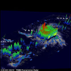
At 1500 UTC (11 a.m. EDT) on May 20, Tropical Storm 04W (TS04W) was located 180 miles (290 km) east-southeast of Yap near 8.3 North and 141.9 East. It had maximum sustained winds near 35 knots (40 mph/65 kmh). On its west-northwest track it is already generating rough seas, with waves up to 12 feet (~3.6 meters) high.
The TRMM satellite flew over rapidly forming Tropical Storm 04W in the western Pacific on May 20, 2011 at 0037 UTC (~10:37 a.m. Local time). This daylight TRMM pass showed that TS04W was becoming much better organized. The TRMM data showed that TSO4W now contained several areas of heavy thunderstorms dropping rain at over ~2 inches/hour (50 mm/hour).
Using TRMM data, Hal Pierce of NASA's TRMM satellite team created a 3-D image of Tropical Storm 04W at NASA's Goddard Space Flight Center in Greenbelt, Md. The 3-D perspective image helps forecasters see the cloud heights within tropical cyclones, giving indications of the storm's strength. The higher the thunderstorms go into the atmosphere, the stronger they are.
The 3-D image was created using data from TRMM's Precipitation Radar (PR). It showed that some thunderstorm towers near TSO4W's center of circulation were punching up to heights of over 9.9 miles (16 km) above the ocean's surface.
Regional warnings have been posted for TS04W. A tropical storm warning is in force for Fais and Ulithi in Yap State. That means that winds of 40 mph (65 kmh) or higher are expected within 24 hours in the warning area. In addition, a tropical storm watch is in force for Yap and Ngulu in Yap State. The watch means that in 48 hours, those areas could experience winds of 40 mph (65 kmh) or higher.
Now, Tropical Storm 04W is on a west-northwesterly track and residents of the northern Philippines should be on guard as it heads in that direction. The current forecast track from the Joint Typhoon Warning Center extends to May 25 and it is not yet expected to be close enough to land at that time. However, in the days after May 25 residents of Luzon, the Philippines may experience the effects of the approaching tropical storm (which is expected to strengthen by that time).
This storm is predicted to become a category 2 typhoon with wind speeds of 90 knots (~103 mph/166 kmh) within five days as it moves toward the west-northwest.
Media Contact
More Information:
http://www.nasa.govAll latest news from the category: Earth Sciences
Earth Sciences (also referred to as Geosciences), which deals with basic issues surrounding our planet, plays a vital role in the area of energy and raw materials supply.
Earth Sciences comprises subjects such as geology, geography, geological informatics, paleontology, mineralogy, petrography, crystallography, geophysics, geodesy, glaciology, cartography, photogrammetry, meteorology and seismology, early-warning systems, earthquake research and polar research.


Newest articles

Superradiant atoms could push the boundaries of how precisely time can be measured
Superradiant atoms can help us measure time more precisely than ever. In a new study, researchers from the University of Copenhagen present a new method for measuring the time interval,…

Ion thermoelectric conversion devices for near room temperature
The electrode sheet of the thermoelectric device consists of ionic hydrogel, which is sandwiched between the electrodes to form, and the Prussian blue on the electrode undergoes a redox reaction…

Zap Energy achieves 37-million-degree temperatures in a compact device
New publication reports record electron temperatures for a small-scale, sheared-flow-stabilized Z-pinch fusion device. In the nine decades since humans first produced fusion reactions, only a few fusion technologies have demonstrated…

