NASA sees Tropical Cyclone Oswald weaken over Queensland's Cape York Peninsula
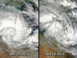
These two images of Tropical Storm Oswald show the storm's progression and deterioration over the Cape York Peninsula, Queensland. The MODIS instrument aboard NASA's Aqua satellite captured these on Jan. 21 and Jan. 22 as Oswald made landfall.<br><br>Credit: NASA Goddard MODIS Rapid Response Team<br>
Tropical Storm Oswald was hugging the southwestern coast of the Cape York Peninsula, Queensland, Australia when NASA's Aqua satellite first flew overhead on Jan. 21 at 0430 UTC (Jan. 20 at 11:30 p.m. EST). The Moderate Resolution Imaging Spectroradiometer (MODIS) instrument aboard NASA's Aqua satellite captured a visible image of the storm that showed tight bands of thunderstorms. Those bands weakened the next day when MODIS captured a second visible image of the storm. At that time, Oswald's eastern quadrant was over land.
On Jan. 21 at 0600 UTC (1 a.m. EST), Oswald had maximum sustained winds near 35 knots (40 mph/64.8 kph). Oswald was centered near 15.8 south and 141.2 east, about 90 nautical miles (103.6 miles /166.7 km) east-northeast of Mornington Island, Australia. NASA MODIS imagery on Jan. 22 showed Oswald's center over the southwestern coast of the peninsula while monsoonal flow was bringing thunderstorms and heavy rainfall to the eastern side of the peninsula. Oswald's maximum sustained winds had dropped to 25 knots (28.7 mph/46.3 kph) on Jan. 22.
NASA also captured an infrared image of Tropical Storm Oswald on Jan. 22 at 0329 UTC with the Atmospheric Infrared Sounder (AIRS) instrument that also flies aboard NASA's Aqua satellite. AIRS data revealed cold cloud tops and strong storms associated with Oswald and a nearby monsoonal trough (elongated area of low pressure) stretched from Cairns north to Cooktown, and over Cape Melville and Lakefield National Parks on the eastern Cape York Peninsula.
At 0600 UTC (1 a.m. EST/U.S.) on Jan. 22, Oswald was downgraded to a remnant low pressure area. The center of circulation was located near 5.0 south latitude and 142.3 east longitude, about 185 nautical miles (213 miles/342.6 km) east-northeast of Mornington Island, Australia, and over the Cape York Peninsula. Infrared satellite data at that time showed the strongest storms were located in the northwestern quadrant. An image from NASA's Tropical Rainfall Measuring Mission (TRMM) satellite on Jan. 22 showed that the low-level center was now stretched across the Cape York Peninsula.
The Australian Bureau of Meteorology (ABM) noted at 10 p.m. Cairns local time (7 a.m. EST/U.S.), that ex-tropical Cyclone Oswald was located over eastern Cape York Peninsula approximately 70 km (43.5 miles) east of Cape Flattery. Oswald was moving southeast at 20 kph (12.4 mph). ABM noted that the monsoon trough (elongated area of low pressure) extended from the ex-tropical cyclone to the east coast near Cairns, which contain the storms that NASA's AIRS instrument saw.
ABM forecasts damaging winds, with gusts to 90 kph (56 mph) with showers and thunderstorms across Cape York Peninsula north of Cooktown. Locations which may be affected include Aurukun, Weipa, Torres Strait Islands, Lockhart River, Coen and Cooktown. Heavy rainfall is likely throughout the Peninsula district, coastal parts of the North Tropical Coast and Tablelands district, and coastal parts of the Herbert and Lower Burdekin district north of about Ayr. The heavy rainfall may also lead to flash flooding. For more information: http://www.bom.gov.au/cyclone/.
Forecasters expect Oswald to linger over the Cape York Peninsula and the Joint Typhoon Warning Center expects Oswald's remnants to continue tracking over land to the southeast.
Media Contact
All latest news from the category: Earth Sciences
Earth Sciences (also referred to as Geosciences), which deals with basic issues surrounding our planet, plays a vital role in the area of energy and raw materials supply.
Earth Sciences comprises subjects such as geology, geography, geological informatics, paleontology, mineralogy, petrography, crystallography, geophysics, geodesy, glaciology, cartography, photogrammetry, meteorology and seismology, early-warning systems, earthquake research and polar research.


Newest articles

Machine learning algorithm reveals long-theorized glass phase in crystal
Scientists have found evidence of an elusive, glassy phase of matter that emerges when a crystal’s perfect internal pattern is disrupted. X-ray technology and machine learning converge to shed light…

Mapping plant functional diversity from space
HKU ecologists revolutionize ecosystem monitoring with novel field-satellite integration. An international team of researchers, led by Professor Jin WU from the School of Biological Sciences at The University of Hong…

Inverters with constant full load capability
…enable an increase in the performance of electric drives. Overheating components significantly limit the performance of drivetrains in electric vehicles. Inverters in particular are subject to a high thermal load,…

