NASA sees Tropical Cyclone Irina still looping at sea
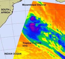
When NASA's Aqua satellite passed over Irina on March 5 at 2211 UTC (5:11 p.m. EST) it captured an infrared image of the storm's cloud top temperatures using the Atmospheric Infrared Sounder (AIRS) instrument. AIRS data showed that the coldest (purple) cloud top temperatures (colder than -63F/-52.7C) that included the bulk of the showers and strongest thunderstorms were on the southern side of the storm. Credit: Credit: NASA/JPL, Ed Olsen<br>
When NASA's Aqua satellite passed over Irina on March 5 at 2211 UTC (5:11 p.m. EST) it captured an infrared image of the storm's cloud top temperatures using the Atmospheric Infrared Sounder (AIRS) instrument. AIRS data showed that the coldest cloud top temperatures (colder than -63F/-52.7C) that included the bulk of the showers and strongest thunderstorms were on the southern side of the storm.
On March 6 at 1500 UTC (10 a.m. EST), Tropical Cyclone Irina had maximum sustained winds near 45 knots (~52 mph/83.3 kph). Irina's strongest winds occurred on March 1, when maximum sustained winds were near 55 knots (~63 mph/~102 kph).
Irina is now about 415 nautical miles (~478 miles/~769 km) southeast of Maputo, Mozambique. The center is near 30.3 South latitude and 39.4 East longitude. It is now moving to the east-northeast.
The forecasters at the Joint Typhoon Warning Center noted that Irina is now “slowly weakening within a marginal environment characterized by cool sea surface temperatures near 25 Celsius/77 Fahrenheit (a tropical cyclone needs temperatures of 22.6C/80F to maintain strength) and moderate, westerly vertical wind shear.” Cool waters and moderate-to-strong wind shear are two factors that weaken tropical cyclones.
Forecasters today at the Joint Typhoon Warning Center are now thinking that those conditions may batter Irina into dissipation in the next day or two, and residents of South Africa and Mozambique are hoping that happens.
Media Contact
More Information:
http://www.nasa.govAll latest news from the category: Earth Sciences
Earth Sciences (also referred to as Geosciences), which deals with basic issues surrounding our planet, plays a vital role in the area of energy and raw materials supply.
Earth Sciences comprises subjects such as geology, geography, geological informatics, paleontology, mineralogy, petrography, crystallography, geophysics, geodesy, glaciology, cartography, photogrammetry, meteorology and seismology, early-warning systems, earthquake research and polar research.


Newest articles

“Nanostitches” enable lighter and tougher composite materials
In research that may lead to next-generation airplanes and spacecraft, MIT engineers used carbon nanotubes to prevent cracking in multilayered composites. To save on fuel and reduce aircraft emissions, engineers…

Trash to treasure
Researchers turn metal waste into catalyst for hydrogen. Scientists have found a way to transform metal waste into a highly efficient catalyst to make hydrogen from water, a discovery that…

Real-time detection of infectious disease viruses
… by searching for molecular fingerprinting. A research team consisting of Professor Kyoung-Duck Park and Taeyoung Moon and Huitae Joo, PhD candidates, from the Department of Physics at Pohang University…

