NASA sees Tropical Cyclone Funso develop, threaten Mozambique
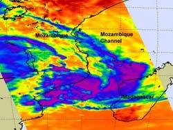
NASA's Aqua satellite captured an infrared look at the temperatures of the clouds in Tropical Cyclone Funso on Jan. 19, 2012, at 10:59 UTC (5:59 a.m. EST). The coldest cloud top temperatures and strongest thunderstorms appear in purple, and were mostly over the open waters of the Mozambique Channel. Credit: NASA JPL, Ed Olsen<br>
At 0600 UTC on January 19, Tropical Storm Funso was located in the Mozambique Channel and about 685 miles (1,102 km) northeast of Maputo, the capital and largest city of Mozambique. Mauputo is located in the extreme southeast of Mozambique. Funso's center was near 17.3 South latitude and 40.7 East longitude. It was moving to the northwest near 5 knots (6 mph/9 kmh). Maximum sustained winds were near 35 knots (40 mph/65 kmh) making it a minimal tropical storm.
Five hours later, NASA's Aqua satellite passed over Tropical Storm Funso and captured visible and infrared data for forecasters.
The Moderate Resolution Imaging Spectroradiometer (MODIS) instrument aboard NASA's Aqua satellite captured a visible look at the clouds of Tropical Cyclone Funso (the eight depression in the Southern Indian Ocean this season) on January 19, 2012 at 11:03 UTC (6:03 a.m. EST).
The MODIS image showed Funso was developing a signature “comma shape” in its clouds – a sign of a strengthening tropical storm. In the image, Funso's highest, strongest thunderstorms were visible around the center of circulation. Those high clouds (powerful, towering thunderstorms) were casting shadows on the lower surrounding clouds.
At the same time, another instrument on Aqua gave forecasters important information about the cloud temperatures of Cyclone Funso. The Atmospheric Infrared Sounder (AIRS) instrument saw that the coldest cloud top temperatures and strongest thunderstorms were mostly over the open waters of the Mozambique Channel at 11:00 UTC. Funso is stretched across the Mozambique Channel from east to west, and the western-most edge of Funso was bringing some moderate rainfall over central coastal Mozambique and the eastern-most extent was raining on western Madagascar.
The forecasters at the Joint Typhoon Warning Center expect Funso to move west then loop around and strengthen just off the central Mozambique coastline. Forecasters and residents of Mozambique are watching Funso's movements closely while still cleaning up from Tropical Depression Dando.
Media Contact
More Information:
http://www.nasa.govAll latest news from the category: Earth Sciences
Earth Sciences (also referred to as Geosciences), which deals with basic issues surrounding our planet, plays a vital role in the area of energy and raw materials supply.
Earth Sciences comprises subjects such as geology, geography, geological informatics, paleontology, mineralogy, petrography, crystallography, geophysics, geodesy, glaciology, cartography, photogrammetry, meteorology and seismology, early-warning systems, earthquake research and polar research.


Newest articles

Properties of new materials for microchips
… can now be measured well. Reseachers of Delft University of Technology demonstrated measuring performance properties of ultrathin silicon membranes. Making ever smaller and more powerful chips requires new ultrathin…

Floating solar’s potential
… to support sustainable development by addressing climate, water, and energy goals holistically. A new study published this week in Nature Energy raises the potential for floating solar photovoltaics (FPV)…

Skyrmions move at record speeds
… a step towards the computing of the future. An international research team led by scientists from the CNRS1 has discovered that the magnetic nanobubbles2 known as skyrmions can be…

