NASA Sees Tropical Cyclone Colin Coming "Unwound"
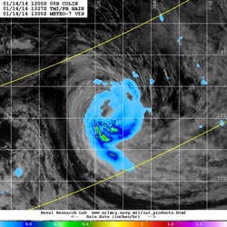
The TRMM satellite flew over Colin on January 14 at 1327 UTC/8:27 a.m. EST and found that light rain surrounded the tropical cyclone with the exception of moderate to heavy rain in the southern quadrant. <br>Image Credit: NRL/NASA/ESA<br>
On January 14, 2014 at 0900 UTC, Colin had maximum sustained winds near 40 knots/46.0 mph/74.0 kph. It was far from land, and centered 1,171 nautical miles/1,348 miles/2,169 km from Diego Garcia near 26.7 south and 73.3 east. Colin was moving to the south at 9 knots/10.3 mph/16.67 kph.
NASA's Aqua satellite passed over Colin at 0840 UTC/3:40 a.m. EST on January 14 and obtained a visible look at the clouds and structure of the storm. The Moderate Resolution Imaging Spectroradiometer known and MODIS captured the image that showed thinning clouds in all quadrants except the southern quadrant where TRMM confirmed the heaviest rainfall was occurring almost five hours later when it passed overhead.
NASA and the Japan Aerospace Exploration Agency's TRMM satellite or Tropical Rainfall Measuring Mission, flew over Colin on January 14 at 1327 UTC/8:27 a.m. EST and measured rainfall in the storm. TRMM found that light rain surrounded the tropical cyclone with the exception of moderate to heavy rain in the southern quadrant.
According to the Joint Typhoon Warning Center, animated multispectral satellite imagery showed that the low-level center of circulation was exposed and after the TRMM overpass, convection has waned more, leaving almost no strong convection in the tropical cyclone. Satellite data showed that the overall low-level structure was becoming less tightly wrapped.
Colin continues to head into cooler sea surface temperatures which will continue to weaken the storm as it is expected to become a cold-core low pressure area. Vertical wind shear is also increasing, so Colin's end is likely in the next couple of days.
Text credit: Rob Gutro
NASA's Goddard Space Flight Center
Media Contact
All latest news from the category: Earth Sciences
Earth Sciences (also referred to as Geosciences), which deals with basic issues surrounding our planet, plays a vital role in the area of energy and raw materials supply.
Earth Sciences comprises subjects such as geology, geography, geological informatics, paleontology, mineralogy, petrography, crystallography, geophysics, geodesy, glaciology, cartography, photogrammetry, meteorology and seismology, early-warning systems, earthquake research and polar research.


Newest articles

Properties of new materials for microchips
… can now be measured well. Reseachers of Delft University of Technology demonstrated measuring performance properties of ultrathin silicon membranes. Making ever smaller and more powerful chips requires new ultrathin…

Floating solar’s potential
… to support sustainable development by addressing climate, water, and energy goals holistically. A new study published this week in Nature Energy raises the potential for floating solar photovoltaics (FPV)…

Skyrmions move at record speeds
… a step towards the computing of the future. An international research team led by scientists from the CNRS1 has discovered that the magnetic nanobubbles2 known as skyrmions can be…

